Zoom-in #1 – Designing an interactive, multidimensional digital platform for urban green infrastructure

InterACT Green aims to develop an innovative digital platform that simultaneously serves as a co-management tool for the various institutions with jurisdiction and responsibilities over the Drava Forest, as well as a public portal offering a range of interactive services to local residents, stakeholders, and tourists.
For this Zoom-in, we sat down with Darko Grabar – Head of the Software Development Department at the Faculty of Organisation and Informatics, University of Zagreb – to explore the platform's development process, architecture, features, and the operational challenges ahead.
Can you describe the general architecture of the platform?
The platform's architecture supports two key roles.
First, it aims to assist urban authorities or various public institutions in managing specific green areas. Second, it is designed to invite the general public, including tourists and residents, to visit and utilise these areas by providing essential services.
From an architectural perspective, we will be using standard web-based technologies, primarily focusing on open-source solutions to ensure sustainability. For the public-facing component, we will likely use an open-source content management system, backed by a custom-developed application. This will serve the needs of the urban authorities. These systems will be interconnected, ensuring seamless data exchange. Users, whether from urban authorities or the general public, will not be aware of these technical distinctions.
What are the key needs that the platform aims to address?
The platform aims to address several needs, primarily derived from its two main user groups:
- For public authorities, which often include city governments and public institutions, the platform will facilitate more effective green area management and enhance communication with the public.
- For the general public, the platform will make green areas more accessible and attractive, encouraging people to visit and engage with these spaces.
What are the most important priorities and features of the platform?
The idea is to create a simple and intuitive system. The main priorities and features include advanced management tools for urban authorities, enabling them to oversee and maintain green areas efficiently. Although we are piloting this in the Drava Forest, the platform is designed to accommodate any green area within a city.
Urban authority personnel will be able to add new green areas, map their locations, and upload relevant resources such as points of interest and maintenance schedules. The platform will also support scheduled maintenance activities, notifying responsible personnel when specific tasks need to be completed. For instance, if a maintenance activity is scheduled, the platform will generate a notification to ensure timely execution.
For the public, the platform will enhance accessibility, encouraging them to step out of their homes and engage with green spaces. Additionally, they will have access to various services through the platform.
The platform caters to different user groups. Could you describe what it will look like for different users?
The platform will offer distinct interfaces tailored to different user roles. For instance, a technician responsible for maintenance will interact with a backend-oriented system designed for desktop use. Meanwhile, personnel from a tourist office will have access to tools for promoting events, publishing news, and managing tourism-related content. The general public will experience a more conventional design, similar to those found in nature park websites, making it intuitive and user-friendly. Public users will not need to download an app. The platform is designed as a web-based application using a mobile-first approach, ensuring accessibility directly via a browser. Given that users often hesitate to download multiple apps, this approach improves usability and adoption.
Can you briefly describe the process you followed to define the platform’s scope and features? It has been quite participatory, correct?
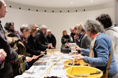
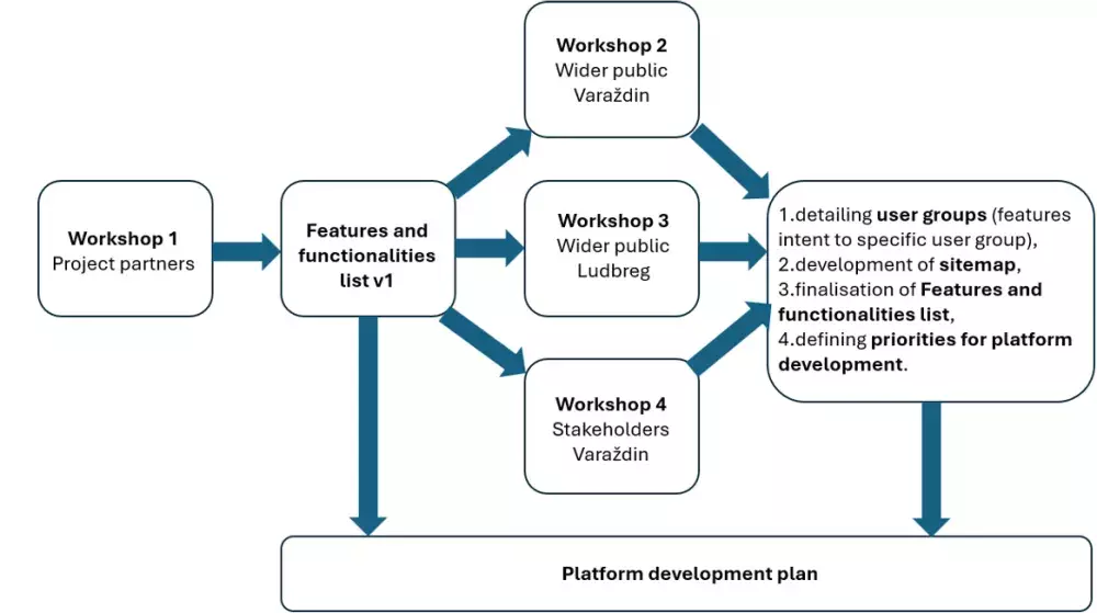
We started with background research, analysing similar solutions and reviewing academic literature on the topic. Following this, we organised an initial workshop with project partners and other relevant stakeholders to identify key user groups and compile a broad list of desired functionalities. We then conducted structured workshops with citizens and the wider public, allowing them to prioritise existing ideas and contribute their own suggestions.
As a result of this process, what will be the core modules of the PLATFORM?
At present, we have identified the following core modules, which will later be populated with specific functionalities and interfaces tailored to the intended users of each.
- GIS Integration and Mapping
- Environmental Monitoring and Health Insight
- Events and activities
- Public Engagement and Feedback
- Training and Knowledge Management
- Content Creation and Management
- Interoperability - Integration with Other Systems
- Asset Management
- Work Management
- Data Analytics and Reporting
- Security and safety
How will you source and maintain data accuracy over time?
To ensure continued engagement, the platform must remain useful to all user groups. Urban authorities will update the system as part of their routine activities—for instance, by logging scheduled maintenance or recording completed work. This, in turn, will inform the public about ongoing developments and allow them to provide feedback.
Will the platform integrate external data sources and technologies such as AI?
We plan to incorporate various data sources through APIs. The platform will consist of two primary components: a content management system and a backend for urban authorities. These will communicate via APIs, and we will integrate additional services as needed.
We are also exploring AI applications, including language models like ChatGPT, to enhance functionality. Importantly, the platform will be designed to interact seamlessly with existing municipal IT systems via open and flexible APIs.
How will you address data management and protection?
Data protection is a significant concern, especially given that we will be handling data from both urban authorities and individual users. We have extensive experience in GDPR compliance—for example, we recently completed a project with our national data protection agency to develop software for SMEs to comply with GDPR.
We will implement all necessary privacy policies, user rights (such as data access and deletion), and robust security mechanisms to prevent data breaches. Additionally, users will be able to track their data usage and manage their privacy settings.
The platform is being developed as part of the Drava Forest project, but it is intended to be scalable. How have you designed it to ensure adaptability for other contexts?
The platform is being developed with scalability in mind. Although Drava Forest serves as our pilot, the system is structured to support green area management more broadly.
Rather than hardcoding specific locations, we focus on generic concepts such as ‘green area’ and ‘public service resource.’ This ensures that cities can configure the platform to suit their needs. New green areas can be added without technical modifications, making it easy to transfer the platform to different contexts.
Will the platform allow for modular expansion?
The platform will include both pre-built functionalities that can be enabled or disabled as needed and a modular architecture for further development. If a city requires additional features not currently supported, IT professionals will be able to develop and integrate new modules without starting from scratch.
Will the platform’s code be open source, and will the documentation be made available for developers?
Yes, we are using open-source technologies, so all code will be publicly available. However, we have yet to finalise the specific open-source licence. Regardless, the platform will be fully accessible, and we plan to provide documentation to support further development and adaptation.
What are the main challenges in the development, release, and adoption of the platform?
The primary technical challenge is designing a universal green area management solution. If we were developing the platform for a single location, it would be simpler, but ensuring adaptability increases complexity. Additionally, interoperability with existing municipal IT systems requires extra layers of development.
How will you ensure adoption by both the public and institutions?
Institutional adoption is a key concern. To address this, we will engage closely with city departments and public institutions throughout the development process, tailoring the platform to their specific needs. If it does not provide clear benefits to municipal stakeholders, it will not be widely used.
Public adoption will be encouraged through an intuitive user experience. We do not anticipate the need for training for the general public. If usability is not self-explanatory, the platform has already failed. However, training will be provided for municipal employees to ensure smooth integration into their workflows.
About this resource


The European Urban Initiative is an essential tool of the urban dimension of Cohesion Policy for the 2021-2027 programming period. The initiative established by the European Union supports cities of all sizes, to build their capacity and knowledge, to support innovation and develop transferable and scalable innovative solutions to urban challenges of EU relevance.

Similar content