VoxPop is delivering the first outputs

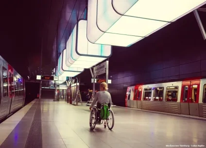
People, Processes & Technology towards the digital transformation of the urban mobility system of Lisbon (VoxPop) is the project that will foster digitalization and collaboration between private and public mobility actors in the Portuguese capital. VoxPop is funded by the Urban Innovative Actions (UIA) initiative under the Digital transition topic. The project is advancing well, presenting significant advances in the different fronts. The innovators Alliance works as a discussion forum where various local stakeholders identify challenges to be overcome and data sets that can facilitate it, as well as the right data sharing framework to allow it; in addition to existing data sets, new data sets will be created, as for example through the client observer app which will allow to collect and manage travellers data; all those data sets will feed the urban mobility observatory, which will be a data repository for the city, not only about mobility but also about energy and the environment; finally, one of the main outputs of the projects is the provision of a navigation support tool for vulnerable city users, which has been co-created with them.
A total of 12 use cases have been raised from 3 members of the Innovation Alliance. In addition, a collaborative process to raise shared challenges among the VoxPop partners has started, delivering the following list:
- Challenge 1: Increasing commercial speed for buses
- Challenge 2: Making dissuasive car parks more appealing
- Challenge 3: Mapping accessibility for persons with reduced mobility (PRM) of journeys on public transport
- Challenge 4: Increase the attractiveness of public transport compared to private car use
- Challenge 5: Prioritize sustainable modes at intersections with higher conflict/competition of flows
- Challenge 6: Increasing the experience of using sustainable modes
- Challenge 7: Improving the cycling network
- Challenge 8: Impact assessment of the introduction of a new bicycle lane in the city
- Challenge 9: Collective passenger transport alternatives more suited to student’s demand
- Challenge 10: Creating mobility hubs to improve accessibility to Lisbon neighbourhoods
- Challenge 11: Identifying bicycle parking needs in the city
- Challenge 12: Prevent the effects of one-off events and natural phenomena that generate higher (and disruptive) demand
- Challenge 13: Factors influencing the use of sustainable modes
In continuation, the governance model requirements of the data sharing ecosystem will be defined following a co-creation approach to accelerate the definition of the framework for effective data sharing among members.
Various analyses have been already executed to support the design of the VoxPop services, generating actionable information and creating a framework to continuously identify opportunities to improve Lisbon's mobility system and to inform public and private companies on how to improve available mobility services or trigger the creation of new services with people-centred qualitative research.
More concretely, the following has been implemented for some of the challenges:
- Challenge 2 (up-left): Mapping of the car parks offer in Lisbon city, the hourly tariffs, the Subscription Prices and of Other Services Available were executed.
- Challenge 6 (up-right): Identify 15 min. walking distance from the defined nodes to the nearest GIRA station.
- Challenge 7 (bottom-left): Identification of areas already with high levels of cycling and without cycling infrastructure.
- Challenge 12 (bottom-right): Analysis of the correlation between the weather condition and the number of trips.
- Challenge 11: identify different types of needs that bicycle users have, to improve the infrastructure and provide better suited services
Based on the above, various value propositions and business models for the various services, such as the car parking, the mobile app of EMEL and the school transport, are being incubated.

Having collected the user needs, analysed and extracted the solution requirements, the next steps were to map and harmonise the datasets and to prepare the data flow so these can be collected in real time. The needs and requirements are listed below:
- Which scheduled vehicles are step free? Show in trip planning and navigations apps whether each bus trip option's vehicle is step free.
- Which bus is arriving? 30s prior to bus arrival, app notifies user which bus it is. Additionally, when bus arrives, a Bluetooth vehicle user connection could be considered to verify which bus it is.
- Which is the next stop? When should I exit? User gets sound signals: i) informing of next stop; ii) alert of exit stop 1 min in advance
- Is the way to the stop accessible? For each stop/station, information is shown about how accessible the local access is [necessary to define how accessibility of the path is defined, including issue of conditions for vehicle to board the stop for a seamless wheelchair transition]
- Is the stop accessible? For each stop/station, information is shown about how accessible the stop is [necessary to define how accessibility of the stop is defined]
- Where is the stop exactly located? Audio indication of location of stop in relation to location of user.
- What is the occupancy level of the vehicle? In the presentation of trip options, show the occupancy level of vehicle [define scale that is understandable both to regular and PRM passengers]
And the functionalities of the solution are the following:
- Information of stop accessibility, what is the comfort level during the waiting time, how easy is to get to the stop
- Inform users of the occupancy level expected from a vehicle
- Information about the bus approaching the stop and, once inside the vehicle, the stop at which you should get off
Next steps are to start the implementation by defining the different methodologies and to map and harmonize the datasets.
Having collected the user requirements in the previous period, the next steps are to design the data infrastructure (back end) and to analyse scalability to more operators. A mock-up of the solution is already available.
Next steps are to validate the specifications with internal bodies and to define the development operationalization model, launching a procurement procedure (if necessary) and to close the implementation plan.
A functional version of the mobility observatory has been already launched and is hosted under the Lisbon observatory on energy, water and other areas. It includes the following indicators:
- Public Transport passengers
- Modal split
- Passengers transported in the different public transport modes
- Frequency of use of public transport
- Length of bike lane network
- Modal split for trips to school
As a next step, the conceptualisation of the monitoring and impact assessment model on the digital transition has been already initiated with the project partners.
All the above outputs allowed to the project partners to increase the visibility of the project, which was present in various relevant events during the last period. Namely:
IT-Trans, 8-10 March, Karlsruhe – “VoxPop - People, Processes and Technology towards the digital transformation of the urban mobility system of Lisbon”
Additionally, a presentation has been accepted at the Transport Research Arena, 14-17 Nov 22: Placing users at the core of mobility products development: the case of VoxPop in Lisbon- Paper submission and at Polis conference 2022, from 30/11 to 1/12.
About this resource

The Urban Innovative Actions (UIA) is a European Union initiative that provided funding to urban areas across Europe to test new and unproven solutions to urban challenges. The initiative had a total ERDF budget of €372 million for 2014-2020.
Similar content