The UPPER project for the urban natural park of the Acque Medie canal

The studies for the project "Canale delle Acque Medie " originate from the working group of Ce.R.S.I.Te.S. (Research and Services Center for Technological and Sustainable Innovation, Latina branch of the La Sapienza University in Rome) as a synthesis of the first results of the research activities underway in the context of the UPPER European project and of the indications emerging from the "Studies for the strategic plan of the city and the territory of Latina".
The intent is to experiment with nature-based solutions (NBS) that are able on the one hand to mitigate the risks of flooding and on the other to improve and strengthen the potential of the entire area by triggering a real process of territorial regeneration.
The proposed objectives, together with the fundamentally important role played by the Canale delle Acque Medie for the city of Latina, constitute an important opportunity for research and experimentation.
At the following link it is possible to view the areas of intervention of the project and a video that represents how the areas will be once the project is completed.
The Canale delle Acque Medie crosses the territory of the Municipality of Latina along the North - South direction, becoming one of the most important ecological connections between the coast and the Lepini Mountains.
Thanks to its considerable extension and proximity to the historic center of Latina, over the years it has acquired an increasingly important role from a morphological point of view, becoming a real reference for the urban development of the North-East sector of the city. However, the very proximity of the urban fabrics, in some cases almost close to the banks, produces problems both in terms of management of the hydraulic risk and in terms of human pressure for the degradation of ecosystems and natural habitats. The Canale delle Acque Medie Project was therefore born from these premises with the intention of using nature-based solutions (NBS) in the urban context affected by the canal.
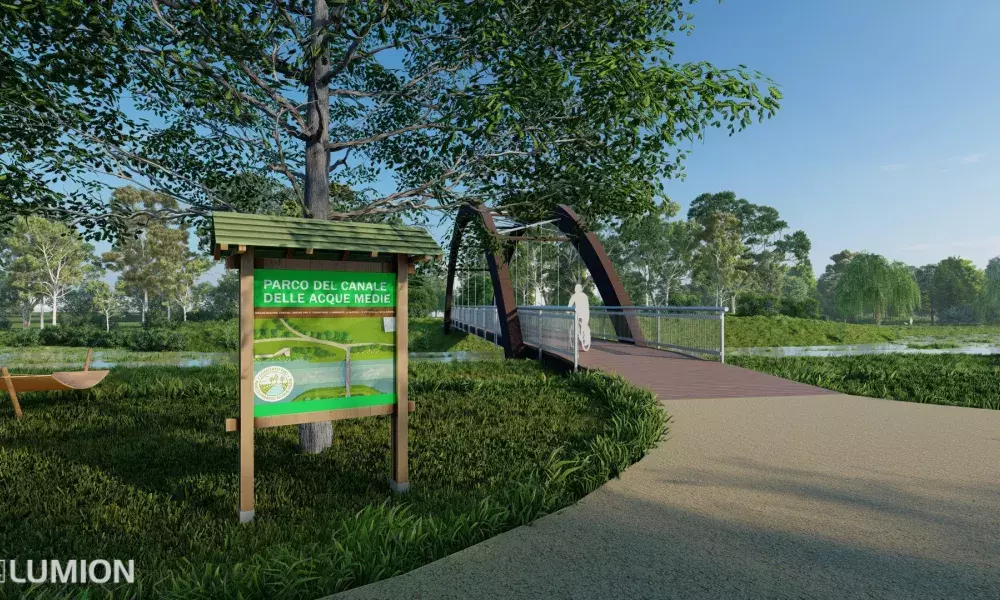
The urban Canale delle Acque Medie Park of Latina, as part of the Upper project, will become a meeting place, emotional recreation, birdwatching, but also an alternative transport system with cycle and pedestrian paths.
Firstly, there will be the restoration of water quality, currently in a serious state of degradation, with the aim of:
• increase biodiversity also according to the role of the canal and Rio Martino as the main ecological corridor between the mountain areas and the coast;
• increase urban quality, overcoming the current condition of marginalization of the canal, through its use by citizens for leisure time and environmental education;
• eliminate the hydrogeological risk due to floods, which have already occurred in the past and are more probable today due to climate change.
The latter is one of the most important points relating to climate change adaptation activities: in fact, the project envisages that the canal will have a wide riverbed that can be attached in the event of an emergency, where the waters can expand without damaging the surrounding structures.
The park will therefore become an urban space rich in flora and fauna biodiversity, with many aquatic species, a beautiful place for naturalistic walks away from urban traffic but close to the whole city. It can be used by students as a real outdoor classroom with didactic-historical-environmental nature trails, to tell the story of the area, the hydrogeological function of the various channels that are under the protection of the Consorzio di Bonifica and the importance of quality of the waters, which also serve to irrigate the fields and then reach the sea.
The Ponte delle Comete (Comet Brige) itself, as well as functioning as a link between two districts, could become, in the context of the urban park, a strategic point for a birdwatching post. A green lung available to citizens for a variety of activities ranging from sports, to teaching and cultural promotion, a river park that can improve the quality of life of the inhabitants and restore a social function of the river by integrating it with the nearby urban spaces to imagine paths of urban trekking, in line with the plans for urban redevelopment and sustainable development of the area. The River Park will thus become the tool for the promotion, development, coordination and integration of projects, initiatives and activities which, through the enhancement of the cultural, historical, territorial, environmental and landscape identity of the territory, can trigger an interesting social economy process shared with the local communities.
The area examined extends from the bridge in Saraceno street along the Fosso del Gionco up to the intersection with the Canale delle Acque Medie and from here it proceeds along the waterway through the Boario, Gionchetto and Pantanaccio districts up to the crossing the Tre Ponti road.
The project proposals were developed according to three main objectives:
1. the mitigation of flood risk, creating suitable floodable areas that reduce the impact of calamitous events such as the last flood that occurred in 2014;
2. increasing biodiversity and the resilience of existing habitats through better ecological connectivity and environmental quality;
3. the regeneration of the housing settlement favoring, where possible, the creation of new services for the community.
The interventions therefore, although designed in an integrated and synergistic perspective, concern three aspects: hydraulic, naturalistic - geotechnical and urban planning.

The mitigation of the hydraulic risk, highlighted by the presence of the constraints of the Hydrogeological Structure Plan (PAI), constitutes one of the founding elements of the project. To this end, the Ce.R.S.I.Te.S. developed a preliminary study regarding the sections, profiles and flow rates of the channel with the aim of developing a model suitable for simulating its performances.
The results obtained showed that the Canale delle Acque Medie presents a state of underdimensioning compared to the flows to which it is normally subject, highlighting some critical points especially at the intersection with the Fosso del Gionco (ditch of the Gionco) where there is the highest risk of flooding. To deal with this problem, it has been thought about the creation of possible bypasses that distribute the excess floods and reprofiling interventions of the embankments by creating expansion basins capable on the one hand of reducing the risk of flooding and on the other of creating potential wet floodable also able to contribute to the recharge of the aquifer. 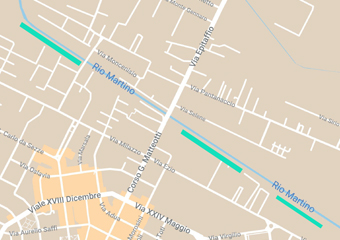
From a naturalistic point of view, the main objective of the work is to strengthen the role of ecological connection played by the Canale delle Acque Medie by mitigating the processes of environmental fragmentation in progress but above all by increasing the resilience of the habitats and biodiversity. The necessary interventions in the hydraulic field constitute an important opportunity which, together with the objectives envisaged by the UPPER project, can support a river requalification process. The UPPER areas located along the course of the canal, falling fully within the housing settlement, give the possibility, as indicated by the naturalists of the Ce.R.S.I.Te.S. to create a mosaic of completely new habitats, even where they have never existed, capable of blending into each other starting from small wetlands, wooded areas, shrubs, meadows up to border areas between forest and pond, able to satisfy both the ecological needs of numerous animal and plant species and for use by residents and visitors.
At the same time, the positive effects on the environment through the creation of new natural areas, in a substantially urban context, will produce carbon dioxide absorption, air filtration, temperature mitigation and improvement of water status. The latter, due to the presence of industrial and civil pollutants, represents a critical issue that must be resolved as a necessary and priority condition for all interventions.

The development of the project from an urban point of view included an accurate analysis of the settlement system, in relation to the results of the ongoing research in the context of the UPPER project. The objective to be pursued is to trigger a territorial redevelopment process that will make the Canale delle Acque Medie assume the primary role of new service axis, supported by the road axes of Ezio and Pantanaccio streets. The proposed interventions, taking into account the urban planning instruments in force and the projects already defined by the Municipal Administration, configure the new structure of the area by providing accesses to the natural areas previously described and based on a dense network of new paths and cycle lanes for mobility. These aim at connecting the two areas defined with the UPPER project of Ilaria Alpi Square demonstration site and the Campo Boario production park, then entering area 2 to reach the bus station. The redevelopment of mobility would therefore be suitable for both walking and fast moving.
In some strategic points, it also appears possible to intervene on the most compromised urban settlements by obtaining new public spaces to be used for free time, recreation and co-working. Finally, zone 2, taking into account the hypotheses put forward in the "Studies for the strategic plan of the city and the territory of Latina" relating to the new railway line that would connect the railway station with the bus lines, would take the form of a gateway to the city assuming not only a strictly environmental value, but also an aesthetic and strategic importance for residents and tourists.
Discussion and open debate between institutions and citizens are the starting point for transforming a mere design indication into what can be configured as a new living environment for citizens and communities who inhabit a territory.

It is important to underline how the " Canale delle Acque Medie” Project represents an important opportunity to experiment with new paths and workshops, aimed at the participation and co-design of public space, which can also be carried out by exploiting the interactive tools implemented in the WHIP platform, activated with the UPPER project, and which is configured as a suitable and inclusive environment for sharing ideas and for supporting reasoning and reflections. Discussion and open debate between institutions and citizens are the starting point for transforming a mere design indication into what can be configured as a new living environment for citizens and communities who inhabit a territory.
The sharing of ideas allows, in fact, to trigger forms of social learning that produce awareness and care, providing simple design solutions with a new communicative power capable of initiating radical and bottom-up processes of regeneration of the territory in which we live.
Co-designing and co-management are in fact the key elements of the UPPER project launched well before the start of the project funded by the UIA call.
As an example, a co-design workshop was held at the end of June 2022 under the arcades of Piazza Ilaria Alpi.
The laboratory was coordinated by the Upper partner Tesserae Urban Social Research project, in collaboration with Cersites Sapienza of Rome and Labirinto social cooperative, with the participation of the Pro Parco Urbano Acque Medie Committee and the Piazza Ilaria Alpi Committee.
The purpose of the activity was to evaluate together the opportunities to be exploited and the critical issues to be resolved.
The studies elaborated by the Cersites Research Center of the Sapienza of Rome constituted a basis for reflection and support for the discussion with and for the citizens within the UPPER project, also with the aim of reconnecting different parts of the city.
The activity was divided into two parts:
– a first phase of presentation of the participants who were asked to contribute with their knowledge on the areas of city under discussion: the Upper partners listened to the voices of the citizens' committees involved, who recounted the activities carried out so far and the inhabitants' ambitions for the future of their respective neighbourhoods;
– a second operational phase of the workshop, divided into two work tables focused on two geographical sections, from the Campo Boario production park to the Ponte delle Comete, and from the bridge to Piazza Ilaria Alpi.
The interaction at the tables touched on 4 different topics of analysis:
1) Identification of urban activities and places in the section being analyzed (e.g. schools, services, areas of significant environmental interest, squares and/or equipped public spaces...)
2) tracing the cycle/pedestrian path, intercepting or connecting the places identified with the highlighting of the critical nodes to be resolved
3) analysis of critical nodes: what is the problem? What are the possible solutions? Who can implement them and how?
4) improvement proposals to the project (for example: areas to be enhanced, existing uses to be maintained, new functions and/or furnishings to be inserted, discussions with stakeholders to be initiated, etc.).
In particular, several topics emerged from the group discussion, including:
• Creation of picnic areas
• Need to involve the expertise and commercial activities present on the banks of the
• Enhance the entrance to the park with a poster, waste bins, an access door
• Provide for a small-sized structure that can be used as toilet, kiosk or refreshment point that also acts as a garrison.
• Create a network among the sports associations present to organize activities along the banks of the canal.
• Organize a more adequate management of the agricultural canals tributaries to the medium water canal,
• didactic communication on the function of vegetation
• re-discussion of the management and protection tools of the banks in relation to the main regulatory limitations (e.g. river contracts)
• installation of protective barriers along the river which limit the transport of any waste
• provide adequate training of personnel who manage green areas, especially on mowing and pruning procedures that are often not adequate for the level of ecosystem complexity to be achieved
• organize information activities on what is being done with public meeting moments and through the Upper WHIP platform which also allows the creation of participatory digital workshops
• involve the territory: the proposal was made to create a questionnaire to be submitted to the inhabitants: “what do you want from a park? what do you imagine for this park?”

The Urban Park of Canale delle Acque Medie is perfectly integrated in the UPPER project and it is also reflected in its deliverables such as:
• Deliverable 4.2.2 "Design of Demonstration Sites": including those referring to the Demonstration Site of Ilaria Alpi Square and to the experimentation site of a stretch of the Canale delle Acque Medie.
• Deliverable 4.1.6 "Co-design workshop on Demonstration Sites": referring in particular to the activity carried out on the occasion of the Upper City Lab in Ilaria Alpi Square in June 2022;
• WP7 "Productive Parks construction" - Investment 1 "Productive Parks" and Investment 2 "Demonstration Sites": the co-design activity in UPPER is closely connected to the construction of the Parks and, specifically, it takes into account the one carried out in relation to the Channel of the Acque Medie because it connects the area of the future PP1-Production Park of Campo Boario and the demonstration site of Ilaria Alpi Square, as well as being itself partly the subject of experimentation in the project.
The meetings to present the studies for the Canale delle Acque Medie Park Project, organized by the CeRSTIeS working group, are also part of the dissemination activities of the Project results included into the Activity A 3.4 "Dissemination Activities".
As a result, we can confirm that the establishment of this river park is an urban redevelopment operation with long prospects, supported by the requests of the citizens and by the many associations which is fully integrated with other public spaces such as Ilaria Alpi Square, San Marco and Vasco da Gama park and the Susetta Guerrini Green Oasis. The urban natural park of the Acque Medie is part of a vision of conscious and respectful use of the territory because establishing this park means protecting the waters from anomalous spills, preventing the abandonment of waste that we have often found there.
For the former councilor for the environment, Adriana Calì, «the urban park and the cycle path are elements of the urban project of the canal, this action has the vision of a sustainable future, to pursue solutions based on nature and on the soul», while the social researcher Roberta Cocchioni, of the coop Il Labirinto, partner of Upper, who has studied the social impact of living outdoors in the greenery, believes that «the project starts with socio-behavioral, sporting, cultural in contact with nature".
The park certainly represents one of the main results that the UPPER project will achieve for the municipality of Latina despite the problems that occurred during the period due to the Covid pandemic and the increase in costs for materials and services. Also for the activities related to the park, the co-design actions with associations and citizens have given a fundamental contribution to the definition of activities and related technical, economic and social results.
About this resource


The Urban Innovative Actions (UIA) is a European Union initiative that provided funding to urban areas across Europe to test new and unproven solutions to urban challenges. The initiative had a total ERDF budget of €372 million for 2014-2020.
Similar content

