Digital technologies have transformed the way we perceive and conceive cities. While data science have been used in urban planning for decades, most of the achievements have remained inaccessible for regular citizens. In the past years, however, it has been increasingly common for technology platforms to develop user-friendly digital spaces that claim to act as public spaces for the digital age. For instance, it has been increasingly common for cities to develop their digital twins. First in Second Life then in the Metaverse, cities have been racing with each other to create their equivalent in the digital space, represented by iconic buildings and landscapes, famous residents or digital services.
However, these digital spaces are shaped by the revenue models of technology companies and delegate to the margins most aspects of urban life that are not considered as profitable or popular enough. There are, therefore, serious doubts if, in these digital spaces, it is possible to create a democratic realm where different voices and stories can be heard and can dialogue with each other.
The DARE project in Ravenna has been investing in another vision of digital space, aiming to build a more inclusive and democratic digital model. By collecting stories and historical resources about the Darsena district, DARE has created a multi-layered chronicle of the area, allowing people to discover their heritage in an interactive and participatory way. In this article, UIA expert Levente Polyak explores the storylabs and the digital archive created by the Bologna University’s FrameLAB, a partner in the DARE project.
The Bologna University is the world’s first university. Established in 1088, it remains one of the best higher education institutions in Europe. The university’s location is not limited to Bologna: some of its specialised faculties are dispersed throughout the Emilia-Romagna region, with campuses in Cesena, Faenza, Forlì, Ravenna and Rimini.
The Ravenna campus historically focused on human sciences, with specialisation in archaeology, digital and cultural heritage, or literature. In recent years, the university broadened its perspective, offering courses in legal studies, engineering and architecture, medical studies as well as natural, political and human sciences.
One of the specialities of the Ravenna campus is its Department of Cultural Heritage, offering a PhD programme in cultural heritage, bringing together knowledge from the fields of architecture, chemistry and physics, as well as civil engineering informatics and legal sciences. This opportunity to bring together different disciplines in one programme gave birth to FrameLAB, the Cultural Heritage Department’s research laboratory, established in 2015 to help synergies between humanities, scientific and technical knowledge.
FrameLAB was born from the experience of young researchers who developed innovative tools for the communication and valorisation of heritage. The research lab was created to improve the way heritage objects, cultural contexts, memories and traditions are conceived and communicated. In collaboration with research institutions, universities as well as museums in Italy and abroad, FrameLAB has been exploring the concept of the “virtual museum,” combining archaeological research with communication and dissemination with the help of virtual and augmented reality, GIS (geographic information system) and digital storytelling.
***
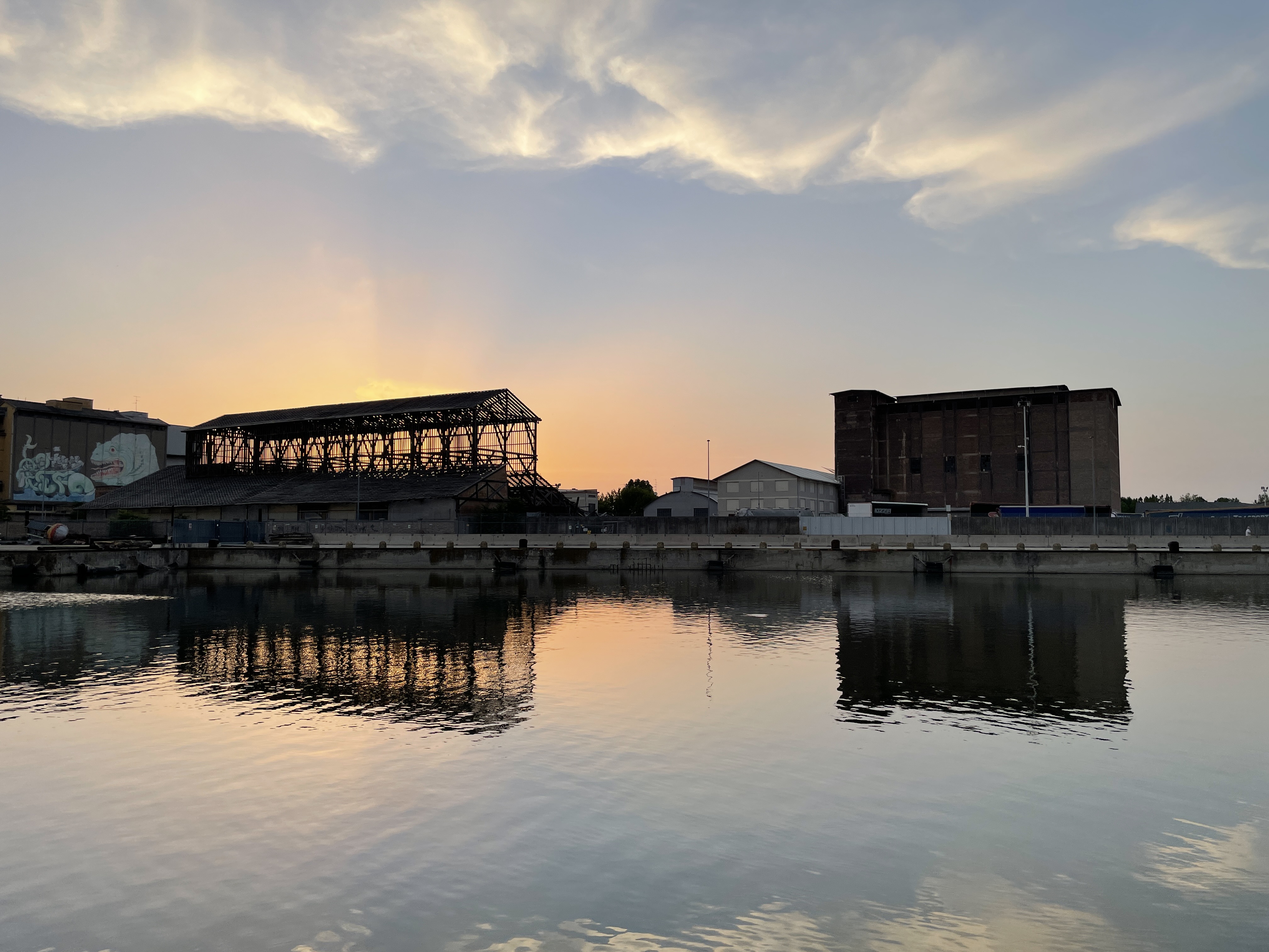
View of the Darsena. Photo (cc) Levente Polyak
I visited FrameLAB on an early Autumn day, to meet Marco Cornaglia, a PhD candidate at the Department of Cultural Heritage, who agreed to explain me the work of his laboratory. FrameLAB is located in one of the four buildings of the department in Ravenna, on a side street just off via Armando Diaz, the main pedestrian street leading to the city centre from the train station. After entering the modernist building, I waited at the reception until my host arrived to pick me up and lead me to one of the laboratory’s offices.
I was kindly reminded to put on my facemask. It was a hot day in Ravenna and by the time we reached the upper floor where FrameLAB is located, I struggled to keep cool under the mask. Marco took me to a room where his colleagues were sitting around rows of computers. Everyone was wearing a mask but no one gave any sign of discomfort: the researchers patiently led me through the various phases of their work.
FrameLAB is truly a melting pot of different professions. “Some archaeologists learn how to use GIS, other students who come from different fields learn how to use a scanner or how to do a digital reconstruction forensic remains. All these cultural competences are part of a new field which is more related to the use of digital humanities.” suggested Marco Cornaglia who is specialised in the use of geographical information systems technologies to valorise cultural heritage and classic literature. In DARE, Marco deals with digital heritage tools for communication and enhancement of the Darsena district.
Within FrameLAB, Marco uses GIS technologies to create digital maps of the Ravenna’s Darsena area. The map is, however, only the beginning: “The issue is how to join a map with a series of information which can be read by the users” underlined Cornaglia. These interactive GIS maps can depict various objects, for instance historical buildings and associate a set of particular information and audio-visual documents with them. Such maps can be also used to take the user on a time travel: “One of the features provided by GIS is the possibility of showing the transformation of a particular feature or a geographical context across time. This is what we try to do with our material: texts, pictures, and documents. We are using this material to show how the area has developed” explained Cornaglia.
The interactive maps that depict a process unfolding in a territory are called storymaps. As their name suggests, storymaps use a software that can embed a variety of content ranging from text to images and videos in order to narrate a story. With their user-friendly interface, storymaps are not aimed only at experts: they are a convenient tool to transmit the results of a research to a broader audience.
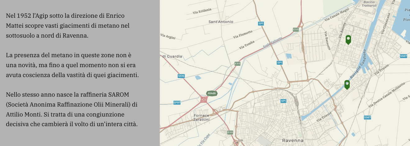
Storymaps can help Ravenna revive a forgotten layer of its past: they can visualise past chapters in its history. They can depict the canals that once crossed Ravenna, making the city resemble to a second Venice, before being buried and forgotten. While Ravenna’s relationship with the Adriatic Sea today is represented by the single Candiano Canal, storymaps can reveal the many links the city cultivated with the sea. “All the history of Ravenna, even if buried, it is still there” suggests Marco Cornaglia. With the help of historical research and storymaps, the city can regain a part of its own past.
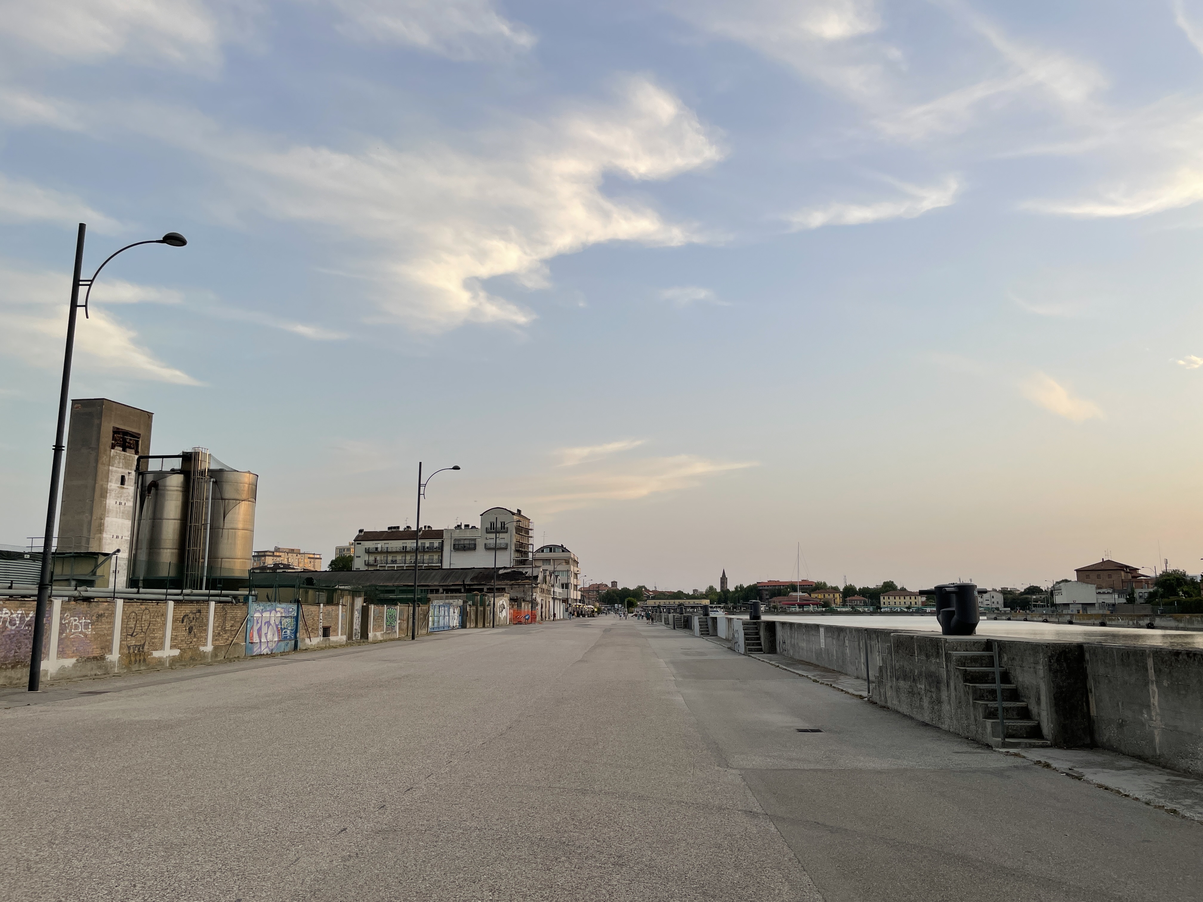
Industrial heritage in the Darsena. Photo (cc) Levente Polyak
Besides being powerful tools to explore the past of an area, storymaps are also useful instruments to outline hypotheses for potential futures. By juxtaposing alternatives for the development of an area, they can make different urban regeneration strategies more tangible. Awareness of different alternatives and their impact on a neighbourhood, in turn, can help citizens become more informed about their surroundings and more active in claiming their rights for a more inclusive, sustainable and healthy environment.
A better awareness of one’s environment and its (potential) transformations is one of the key ambitions of DARE. Empowering residents with knowledge about their neighbourhood in the form of data, strategies and stories can help them make more informed decisions and choices when backing or opposing a development scenario for the Darsena. Invited to propose initiatives and vote on the urban development “tactics” most suited to their needs, Darsena residents are encouraged to be an active part of the area’s future. And to shape the area’s narratives: the storymaps designed by FrameLAB also include photos, videos and texts shared by local residents.
***
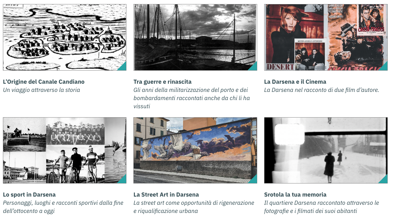
After their long introduction, Marco and his colleagues sat down with me in front of a computer and guided me through the DA.LI.A, the digital archive of the Darsena, constituted by the interconnected storymaps. Scrolling through the maps, I realised the wealth of materials collected in the 26 storymaps published at the DARE project’s digital platform. The maps paint a rich image of the Darsena’s past century, ranging from the chronicle of the Candiano Canal and its changing economic character through the story of some of the key enterprises of the area and to the cinematographic depictions of the Darsena.
Storymaps. Image (c) darsenaravenna.it
We chatted for another quarter of an hour before I left the laboratory. I thanked Marco and the team for their time, and slowly descended to the street. Impressed by the stories I just saw in FrameLAB, I decided to walk back to the railway station and cross under the rails for another walk in the Darsena. Strolling along the canal, I recognised the traces of past developments depicted by the storymaps. I went online and began scrolling through the storymaps, curious about the stories behind the facades of some of the most characteristic buildings.
The storymaps made me notice many details of buildings, public spaces and objects that had evaded my attention before. This is the digital heritage of the Darsena, many interconnected stories that constitute the building blocks of several possible futures of the area. While I walked back along the canal towards the station, the maps kept working in my head: they guided my steps between different eras and possibilities.
About this resource
Author
Levente Polyak
Project
DARE - Digital Environment for collaborative Alliances to Regenerate urban Ecosystems in middle-sized cities
The Urban Innovative Actions (UIA) is a European Union initiative that provided funding to urban areas across Europe to test new and unproven solutions to urban challenges. The initiative had a total ERDF budget of €372 million for 2014-2020.