Ce.R.S.I.Te.S. and the importance of NbS monitoring for strategic planning

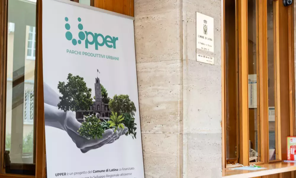
The UPPER project takes a comprehensive approach by integrating greenery, green infrastructure, and innovative outdoor services and activities. It aims to revitalize underutilized urban areas, creating Demonstration Sites for testing self-produced NbS interventions such as phytoremediation, indigenous tree planting, and soft engineering measures. The Productive Parks have been co-designed and will be co-managed by project partners, local citizens, and stakeholders, with a focus on long-term maintenance and sustainability. The initiative also explores the Green Areas Bank to meet the demand and supply of NbS, while integrating a job and skills program for vulnerable citizens. Support for social enterprises and for-profit startups ensure market exploitation and further development of the Productive Parks, ultimately aiming for wider implementation and impact.
For the Upper project, together with the Municipality of Latina, 7 partners worked trying to develop the design and construction of Productive Parks and Demonstration Sites according to the objectives of the project, which can be classified as environmental, urban, economic and social and summarized in three main ideas:
1. focus on the self-production and self-maintenance of NbS, with technologies that enable Public-Private-People Partnerships (PPPP), with a view to ensuring long-term sustainability and the extension of good practices at citizen level;
2. link the implementation of NbS to social benefits such as the employment inclusion of marginalized groups, mental health care and social cohesion;
3. promote the formation of an NbS market through "productive parks", encouraging the development of new businesses with new business models on the supply side and stimulating the formation of demand from inhabitants and public and private stakeholders.
The implementation of Nature-based Solutions (NbS) in urban environments is gaining momentum as a means to address environmental challenges and promote sustainable development. However, effective monitoring and evaluation are essential to assess the performance of NbS interventions and to guide decision-making. One of the main UPPER partners was Ce.R.S.I.Te.S. (Centro di Ricerche e Servizi per l'Innovazione Tecnologica e Sostenibile / Research and Services Center for Technological and Sustainable Innovation). Ce.R.S.I.Te.S. is the interdepartmental centre approved as a Sapienza University of Rome research and services centre. It pursues the aim of managing and promoting institutional research activity, the management and promotion of teaching support services carried out at La Sapienza - Latina branch. It brings together researchers active in environmental, biological and economic areas. It boasts many years of experience in sustainability, energy and environmental planning also in collaboration with local authorities and companies. For the UPPER project it was the point of reference for monitoring the NbS results, the interpretation of the environmental solution as well as the socio-economic data produced by the various partners.
The emergence of NbS reflects a growing recognition of the need to collaborate with ecosystems to adapt to and mitigate the effects of climate change, while simultaneously enhancing sustainability and preserving the integrity of natural environments. In the context of urban areas, NbS rely on utilizing or creating natural features and elements within and around cities to provide essential ecosystem services. These services, in turn, contribute to various aspects of sustainable urbanization. NbS have the potential to address multiple interconnected challenges at different scales. These challenges include (i) fostering economic development in urban areas, (ii) enhancing the social aspects of sustainable urbanization, and (iii) generating positive environmental impacts. In terms of environmental benefits in urban areas, this encompasses the regulation of climate, air quality, water treatment and purification, natural hazards and waste management, erosion control, green space management, pollination, and more.
Environmental issues had always been considered by the Municipality of Latina in relation to the well-being of the inhabitants and only marginally with respect to the protection of biodiversity. This orientation, evident in the choice of the areas of intervention for the UPPER project, presented clear limits. The Ce.R.S.I.Te.S., and in particular its urban planning component, urged the partners and the Municipality to adopt a transdisciplinary approach to the formulation of the intervention proposals. With this change of approach Ce.R.S.I.Te.S. tried to give the protection of biodiversity the space it deserves through the assumption of green and blue infrastructures as a strategic element of the project and a link to the other NbS, in reference to the definition of the European Commission and its role as a broader network of connections of which ecological networks are the backbone
The fundamental action to create the green and blue infrastructure network therefore consists in using and valorising in an ecological key the complex hydrographic network managed by the Pontine Reclamation Consortium with afforestation and vegetation redevelopment interventions on the banks of canals and ditches, associated with the creation of lamination areas for floods and groundwater recharge, as well as the provision of equipment and cycle/pedestrian paths for the well-being of the inhabitants and tourism enhancement. To this end, naturalistic surveys were carried out on the vegetation characteristics and faunal presences, integrated with analyses on the urban, economic and social aspects present in this context.
Part of the Ce.R.S.I.Te.S. working group employed proximal and remote sensing techniques (Bonifazi et al., 2022), based on the use of visible and near-infrared (NIR) spectroscopy and remote sensing data from the satellite constellation of the Sentinel-2 mission, with which various indices can be calculated to evaluate the vegetation cover, the water supply of the vegetation of the various sites under study and carry out multi-level monitoring of plant health. At the same time, the environmental characterization of the sites was defined through simulations based on OpenFOAM, an open-source fluid dynamic solver that allows us to estimate how the air flow relating to the winds that hit the entire city of Latina interacts with the structures present in the urban area. Thanks to the availability of geo-spatial data from urbanized areas, it was possible to reconstruct the three-dimensional model of the buildings which, integrated with analyses of air temperature distributions, allowed the creation of a thermo-fluid-dynamic simulation model capable of providing indications on some critical areas for the heat island and on the role played by the planting interventions carried out or planned. All the analyses were inserted into a GIS project developed with Qgis software, which allowed the development of an information system of the study data. The GIS project was then published on the web through the WHiP platform (WebGIS Holding interactive Platform) implemented with Lizmap software: https://lpdt.cersites.uniroma1.it/index.php/view/map?repository=upper&project=UPPER_WHIP This platform, connected with data from Engie's monitoring stations, allows Ce.R.S.I.Te.S. to return to the public the evaluations of the effects of the interventions and deepen the reflection on the types of NbS proposed.
In each case study, and for UPPER project too, it was crucial to verify the impacts of NbS through monitoring and evaluation processes. This verification not only provides evidence but also informs the decision-making process, allowing for adaptive management. In order to ensure sustainable and resilient development in the face of climate change, urban planners in both the public and private sectors must establish a baseline, adequately monitor and assess the impacts of NbS interventions.
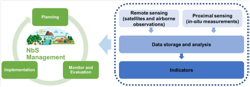
In this context, visible and near-infrared (Vis-NIR) spectroscopy can be seen as a valuable tool for monitoring NbS implementation. Such a technique utilizes the absorption/reflection properties of light to analyse the composition and characteristics of materials, including vegetation and soil. Vis-NIR techniques are widely used in the agri-food sector for different purposes and for soil analyses. In this scenario, the utilization of this sensing technique, both at ‘proximal’ and ‘remote’ scale, enables non-destructive and rapid assessment of key parameters related to plant health, nutrient content, and overall ecosystem functioning. Earth Observation (EO) data, acquired from satellites or aerial platforms, provide broad-scale and multi-temporal information on vegetation dynamics, land cover changes, and ecosystem health. This allows for the assessment of NbS’ impacts on a larger spatial scale. Proximal sensing, on the other hand, involves the use of handheld or ground-based sensors to collect high-resolution data on specific parameters such as plant stress, biomass, and soil moisture. Proximal sensing enables detailed monitoring at a local scale and facilitates real-time decision-making for NbS management.
Remote and proximal sensing techniques, such as NIR spectroscopy, contribute to NbS management, especially in the monitoring and evaluation stage. Those techniques allow us to verify the environmental positive impacts of NbS. However, such impacts have to be verified through monitoring and evaluation phases from an adaptative management perspective. The approach presented by Ce.R.S.I.Te.S. focuses on the application of remote sensing and proximal sensing techniques, supported by meteo-climatic data, for the environmental monitoring of NbS interventions. Specifically, in the UPPER case, environmental monitoring refers to the assessment of changes from the ex-ante phase (or baseline state) to the NbS implementation phase, in terms of plant health and vegetation area evaluation. The study seeks to provide a comprehensive understanding of the environmental changes resulting from NbS interventions by combining remote sensing data at a broader scale, to evaluate specific indicators at a synoptic level, and point spectroscopy data at a localized and small-scale level. This integrated approach enables the evaluation of plant health and vegetation areas, contributing to a more comprehensive assessment of the effectiveness and impacts of NbS interventions.
Field-based proximal sensing techniques (i.e., near-infrared spectroscopy, NIR) and satellite-based remote sensing data from the Sentinel-2 mission were employed. By integrating these techniques, the study enables comprehensive and multi-scale monitoring of vegetation health and assessment of green areas. Various band ratio indices are calculated to assess vegetation coverage, water content, and urbanization. Temporal variations in these indices are analysed to evaluate the effectiveness of NbS interventions and their impact on the urban environment. The combined approach of proximal and remote sensing demonstrates the potential for comprehensive and multi-scale monitoring of NbS in urban environments. The research findings contribute to the existing knowledge on NbS monitoring and evaluation, providing valuable insights for sustainable urban development and evidence-based decision-making.
To obtain fundamental information regarding the most representative plant communities in the area, which serves as a reference for evaluating the effects of intervention success, non-invasive and non-destructive analyses were carried out. These analyses involved spectroscopic investigations that focused on assessing the chemical and physical characteristics of the leaf surfaces of selected tree individuals, which were considered as reference points. The investigations employed innovative monitoring techniques based on digital spectrophotometry in the NIR range (i.e., 1000–1700 nm). This range of wavelengths allows for the measurement of various leaf properties related to photosynthetic pigments, water content, and structural features. By utilizing these advanced spectroscopic methods, valuable insights into the physiological status and health of the plant individuals were obtained without causing any harm or disruption to their overall well-being. Proximal sensing indices were evaluated from reflectance spectra. These indices are based on the corresponding remote sensing indices, providing information about vegetation status and estimates related to water content and Leaf Area Index (LAI). To assess the change from the ex ante state (or baseline state) to the intervention state of the UPPER areas in terms of plant health and vegetation evaluation, a study using satellite imagery was conducted.

AOIs of planned NbS intervention areas within the UPPER project (5 May 2023): CAMPO BOARIO (a), MERCATO (b), AUTOLINEE (c), PIAZZA ILARIA ALPI (d), VIA GOYA (e), and VIA LEGNANO (f).
The average reflectance spectra of each analysed plant are shown in Figure 8. The figure shows characteristics and absorption patterns that are associated with various biochemical and structural components. In more detail, a significant drop in reflectance can be observed between 1400–1500 nm. This is caused by the strong absorption of water molecules in the leaf tissues, indicating the presence of water content in the plant. Beyond 1500 nm, the reflectance gradually increases due to the presence of different chemical compounds, such as cellulose, lignin, and other structural components in the plant cell walls.

Figure 8 Mean reflectance spectra of the acquired plants prior to NbS planned intervention (2020): CAMPO BOARIO (a), MERCATO (b), AUTOLINEE (c), PIAZZA ILARIA ALPI (d), VIA GOYA
Normalized Difference Vegetation Index (NDVI) is a popular remote sensing index used to measure and monitor vegetation health, density, and coverage. It leverages the reflective properties of vegetation in the red and near-infrared (NIR) wavelengths of the electromagnetic spectrum. NDVI values range from -1 to +1, where higher values indicate healthier and denser vegetation. Generally, an increase in the NDVI index signifies a healthy ecosystem and high vegetation productivity. However, an excessively high increase in the NDVI index could be indicative of excessive vegetation growth, which could be a result of inadequate land management.
The Normalized Difference Water Index (NDWI) is a remote sensing index used to detect and monitor water bodies, including their extent and changes over time. It exploits the reflective properties of water in the green and near-infrared (NIR) wavelengths of the electromagnetic spectrum. NDWI is valuable for hydrological studies, water resource management, and environmental monitoring. An increase in the NDWI index indicates a higher water uptake by plants, which can be attributed to increased vegetation biomass, greater water availability, or improved hydraulic efficiency of plants. This increase may also be indicative of enhanced vegetation productivity, increased herbaceous biomass, and other indicators of ecosystem health. Additionally, an increase in the NDWI index can be influenced by weather conditions, soil quality, and water availability.
The annual variations that occurred during the baseline time interval, 2015–2022, and 2023 in the NDVI and NDWI for each analysed site are reported in the following table:
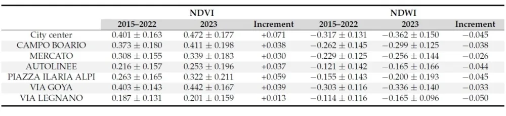
Table NDVI and NDWI variations (baseline 2015–2022 and 2023) for the city center of Latina and UPPER project sites
The information collected by Ce.R.S.I.Te.S. has been used to inform decision-making processes related to water management, landscape planning, and NbS implementation to enhance urban resilience and sustainability. Further research and analysis are needed to explore the implications of these indices’ variations in relation to local environmental conditions, land management strategies, and long-term urban development goals. Assessing the success and effectiveness of NbS requires considering a broader range of indicators, including ecosystem services, social benefits, and resilience to environmental challenges. Site-specific factors, management practices, and local environmental conditions should also be considered when interpreting the results.
Based on the analyses carried out, Ce.R.S.I.Te.S. has defined an abacus/schedule of the NbS considered during the project (see below). The abacus is divided into six categories which contain the solutions applicable to urban and peri-urban areas: Solutions for construction; Furnishing solutions for green areas; Solutions for mobility infrastructures and public space; Solutions for the abiotic system; Solutions for the movement and resting of fauna; Solutions for utility and sociability through plants

To significantly contribute to the protection of biodiversity, native or historic species have been selected for the Upper areas, recognized not only for their ecological value but also for their identity-landscape value. Interventions have therefore been proposed to improve connections with external areas, also through the construction of eco-tunnels where the Upper area is confined by road infrastructures, and natural refuges have been secured (areas left in the wild with a limitation of interventions) as well as structures, such as artificial nests, to encourage nesting/reproduction. Other fundamental elements of the planning proposals are the restoration and conservation of permeable surfaces, as well as the containment of water flow, the recharge of the aquifer, the accumulation of rainwater to improve plant life.
A specific mention deserves the demonstration site of the Acque Medie Canal on which the Ce.R.S.I.Te.S. has developed a structure hypothesis which is proposed as an example of a complex intervention, which can also be reproduced in other sections of the hydrographic network of the Pontine territory. The project, integrating hydraulic modeling with naturalistic, geotechnical and urban planning interventions, involves the creation of lamination reservoirs that do not modify the artificial bed of the Canal but only its banks through terrain modelling. In this way, the hydrogeological risk is reduced, improving the recharge of the aquifer, creating environments suitable especially for avifauna and of high quality for public use, supported by cycle-pedestrian paths and places for meeting and observing birds.

Ce.R.S.I.Te.S. created the WHiP platform to easily view and query the cartographic layers and databases emerging from the studies. It allows to see and download the renderings and videos developed to represent the hypotheses for the arrangement of the intervention areas. Its interactive character is linked to the possibility of a user inserting comments, documents and, finally, drawing symbols and polygons with very simple tools, using the platform layers as a basis, sharing the drawings with other users. These capabilities make it a tool that can give continuity to participatory processes, allowing, in the time between one workshop meeting and another, to expand the number of participants and deepen the discussion.

The Ce.R.S.I.Te.S., in collaboration with the other partners, also carried out a listening and discussion activity with local companies, identifying the elements to allow, through the awarding of a municipal concession, the production of native plants and at the same time guarantee, with the possible association of other companies dedicated to socio-cultural services, the provision of recreational and cultural services to the inhabitants. In parallel to these activities, the Caetani Foundation, with the collaboration of Labirinto, has trained 'production park operators', professional figures specialized in the cultivation and maintenance of greenery and plants, with skills in welcoming the public, environmental communication, management and organization of urban production parks. This plant production model has a double value: on the one hand, bringing the inhabitants closer to the horticultural activity and the different types of NbS; on the other, to have the Municipality of Latina playing the role of promoter of the green transformation process of the urban areas of the cities within the bioregional territory.
The work carried out by Ce.R.S.I.Te.S. team for the UPPER project has demonstrated how it is necessary to use urban strategic planning that includes the use of NbS as well as green and blue infrastructures without making the protection of biodiversity marginal. But this is not central only for the design phase. The researches carried out by Ce.R.S.I.Te.S. highlighted the importance of monitoring and evaluating environmental performances of NbS interventions in urban contexts and showcased the role of proximal and remote sensing techniques in achieving comprehensive assessments. As specifically seen for the UPPER project, by combining Earth Observation data and proximal sensing, a comprehensive and multi-scale monitoring approach for NbS can be achieved. The results achieved by adopting proximal and remote sensing indices showed that both approaches allowed for correct area monitoring. Local level vegetation health assessments using proximal sensing techniques will be essential to individually evaluate the status of the plants undergoing intervention. It is crucial to consider, in fact, that each plant species may have distinct requirements and tolerances, thus emphasizing the importance of considering the environmental context and plant-specific characteristics during the interpretation of future results at a larger scale.
This integrated approach adopted by the UPPER project significantly enhances our understanding of NbS’ effectiveness, allowing for targeted interventions and evidence-based decision-making in the context of sustainable urban development. By combining these monitoring techniques, stakeholders can gain a holistic view of NbS’ environmental impacts. This knowledge is essential for designing and implementing effective NbS strategies that address the challenges faced by urban environments. The integration of these monitoring approaches will contribute to a more sustainable and resilient future, where NbS play a vital role in addressing environmental challenges and promoting well-being in cities.[1] Finally, the work of Ce.R.S.I.Te.S. has demonstrated how strategic planning processes can constitute a privileged area of intervention to protect common goods, but they must however be supported by territorial projects and broad and courageous visions of the future, which integrate a bioregional vision of "wide area", making citizens more aware of environmental problems and the importance of NbS.[2]
[1] Bonifazi, G.; Gasbarrone, R.; Serranti, S. Assessing the Environmental Performances of Nature-Based Solutions Implementation in Urban Environments through Visible and Near-Infrared Spectroscopy: A Combined Approach of Proximal and Remote Sensing for Monitoring and Evaluation. Sustainability 2023, 15, 16076. https://doi.org/10.3390/su152216076
[2] Sotto l’ombrello delle nature based solutions. Il caso del progetto Upper del comune di Latina / Budoni, Alberto. - In: CONTESTI. - ISSN 2038-6583. - 2/2023(2023).
About this resource


The Urban Innovative Actions (UIA) is a European Union initiative that provided funding to urban areas across Europe to test new and unproven solutions to urban challenges. The initiative had a total ERDF budget of €372 million for 2014-2020.
Similar content

