Time2Adapt Zoom-In N°1: Where to experiment? Use sensitive and physical diagnoses to ask citizens and rough data first!

Many municipalities wish to be at the forefront and support their residents and users to face heatwaves. They wish to provide water fountains, natural and artificial shadows, (new) parks, (new trees), (new) cool infrastructure, or to open them during increased or readjusted timings to fit with heatwaves. At least, this is what the Lille European Metropolis (MEL) is seeking to achieve through a time-based approach. Yet, how can a local authority, and in this case MEL, adapt to heatwaves with limited resources both in terms of land and money? How can a local authority identify the best locations to experiment these solutions? How can it ensure that the choice takes into consideration urbanistic and natural realities as well as the habits of those using the city?
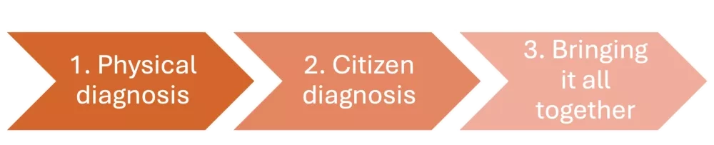
Time2Adapt sought to circumvent this challenge by developing two complementary diagnoses: a physical diagnosis, and citizen “sensitive” diagnosis. This ZoomIn presents the 3 steps for this process together with their results, successes and challenges, as well as main takeaways for other interested local authorities and stakeholders.
The need for a diagnosis
In order to start experimentations as early as summer 2024, the partners of Time2Adapt had already identified locations for these to take place in the cities of Lille and Loos: furniture had already been installed at the garden of Maison Folies Moulins, and four schoolyards of Lille and Loos had tested opening during the summer. The project was still in need to build scenarios to identify more places in Lille and Loos to be transformed through light transformations (facilitated access, light equipment, one-off transformations, …), optimisation of opening hours, hosting of temporary installations, and through intensification of usage. These scenarios were meant to address populations deemed to be vulnerable due notably to the area and dwelling they live in.
This identification had to be based on a thorough analysis of the existing situation. It was therefore decided to carry out two complementary diagnoses: a physical diagnosis and a citizen diagnosis which led to the identification of sites for the future project’s experimentations. The three steps then served as the basis for a refined methodology for the project and beyond.
Step 1: physical diagnosis
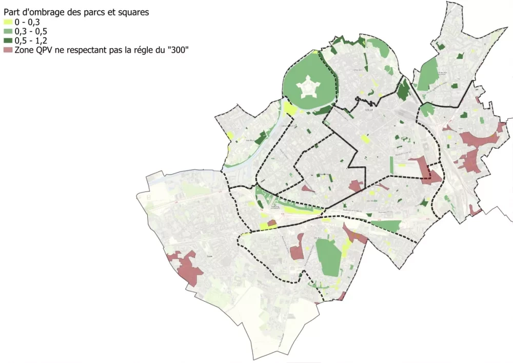
The physical diagnosis aimed at analysing the objective (lack of) coolness of the cities of Lille and Loos, based on scientific data. For this purpose, the 3-30-300 approach was used.
1.1 Process
In 2021, Dutch urban planner Cecil Konijnendijk proposed the 3-30-300 rule to focus on the crucial contributions of urban trees and other urban nature to urban health and wellbeing, as well as climate change adaptation. Every city dweller should be able to:
- see at least three trees from their home or working spaces: this improves mental health and wellbeing thanks to visual contact with nature;
- live in a neighbourhood with at least 30% of wooded area: this fosters microclimate, reduces urban heat islands and improves air quality, and
- live less than 300 meters from a green space: this promotes physical and social activities while reducing stress.
Time2Adapt used this approach to identify the needs for cool time-based solutions in the Metropolis.
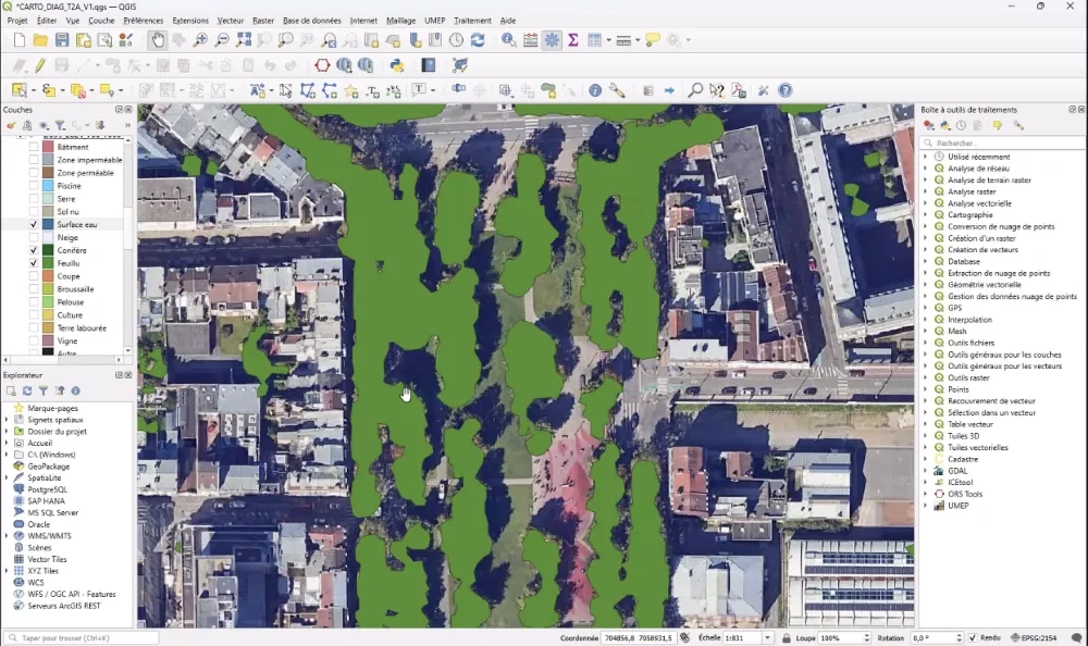
For the city of Lille, data was easily available as the city maps it trees and parks, and that CEREMA, the partner in charge of this task, started by using its own data. For the city of Loos, nor the city nor CEREMA possessed data on the number of trees and the size and type of (small, medium, shadows) tree coverage. Yet, at a later stage, the Cosia database, was discovered and used: it uses Artificial Intelligence to analyse aerial pictures, produced by the French IGN (Institut national de l'information géographique), which actually covers the entire country.
Further data was gathered to be included in the maps:
- List of cool places, based on the mapping already carried out by MEL
- Opening hours of parks, available publicly for Lille and provided by the municipality directly for Loos
- City priority areas
These activities were led by CEREMA with the involvement of MEL.
1.2 Results of the analysis
The analysis produced maps of the two cities combining:
-
- The presence of parks and their dimensions,
- The importance of shade and canopy,
- City priority areas, and
- Opening hours of parks and cool places.
The maps were useful to identify where some green areas exist but are sometimes too small. These areas could be made greener with small investment : this approach enables providing the right scale to (renovation)works.
In Lille, a network of green spaces is generally observed, but sometimes lacking shade to guarantee satisfactory freshness: an improvement of the existing would be quite useful, without necessarily incurring large investments (as such, at a lower cost). Loos has few parks, with only some neighbourhoods well wooded.
Step 2: Citizen Diagnosis
The aim of the citizen diagnosis was to collect feedback from residents and users as to their habits in period of heatwaves (above 30°C). In other words, what do they do or where do they go to when the weather is too hot, and what else would they like to do or where to go to?
2.1 Process
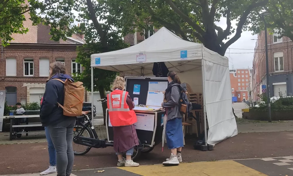
Between June and September 2024, residents and users were met in a total of six sectors (four in Lille and two in Loos), five of them classified as ‘City priority areas’. The sites were selected based on the partial physical diagnosis, decisions within the consortium and in close collaboration with elected representatives and technicians from the 2 cities.
In the French local context, a QPV (Quartier Prioritaire de la Politique de la Ville), or Priority District of City Policy, refers to an urban area designated by the government for targeted social and economic support. These districts meet two main criteria:
- They have a minimum population of 10,000 inhabitants.
- They face significant income disparities compared to both the national average and the surrounding metropolitan area.
The QPV designation allows for public policies and funding to be directed towards improving living conditions, economic opportunities, and social cohesion in these neighborhoods.
Four parallel devices were then implemented to collect a maximum of user expertise:
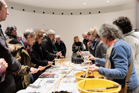
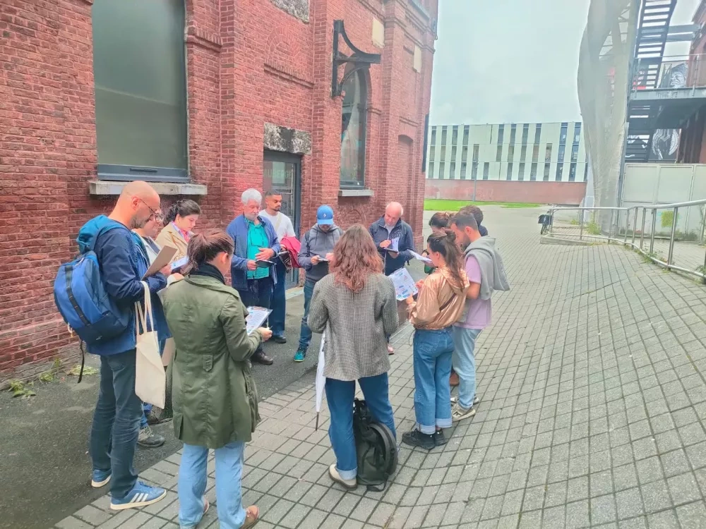
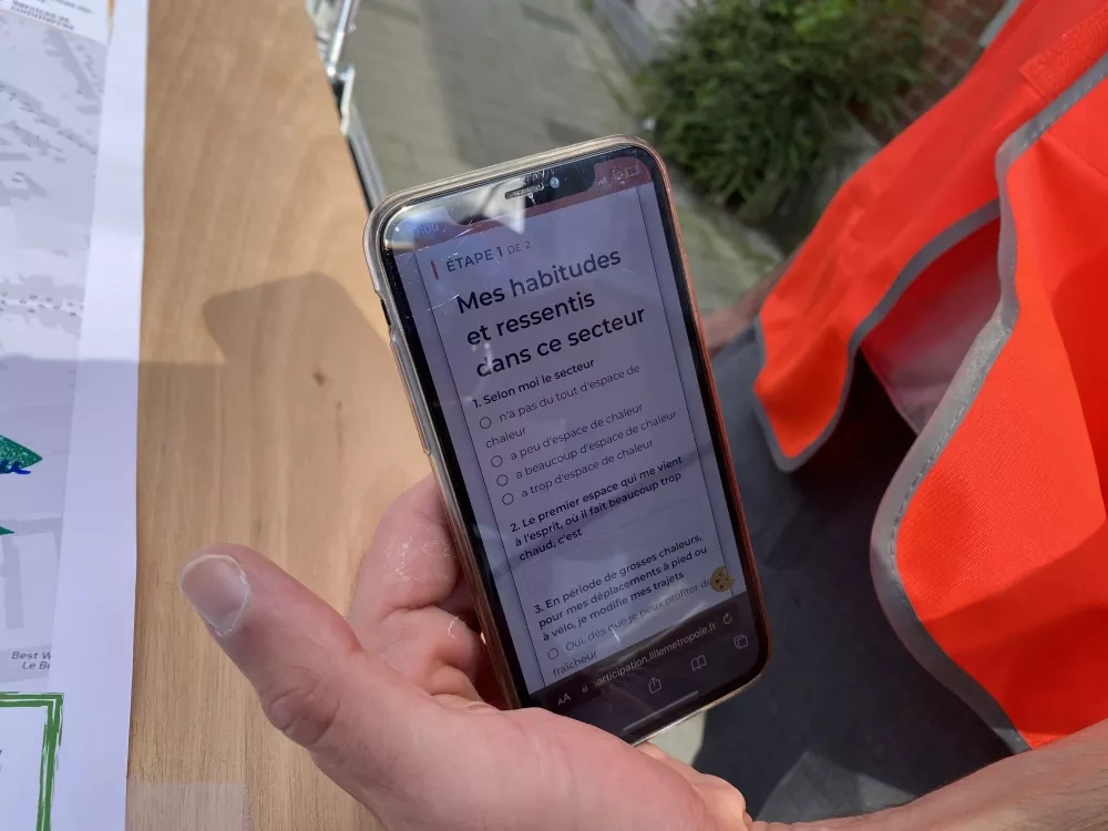
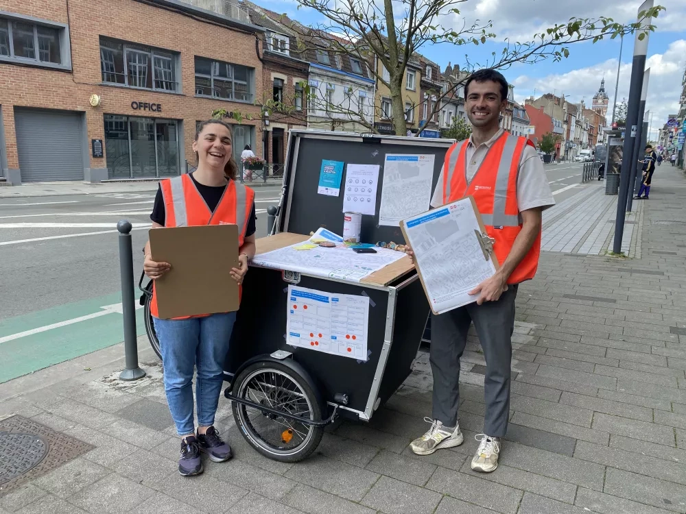
- Seven mobile stands, with 130 participants, mapped the (current and desired) uses of the spaces and feelings of the warm and cool spaces by residents and users.
- Six sensitive walks, with 20 participants, questioned the practices and feelings of freshness in different places as well as the routes between places.
- Five online questionnaires, , with 210 respondents, collected the habits and wishes of residents and users of the six sectors regarding heat and the habits linked to it.
- Other activities were organised : a neighbourhood council on heat, as well as 30 participants during a workshop in retirement home and a meeting with local NGOs.
These activities were led by Ecologie Urbaine Citoyenne (EUC), with the involvement of MEL and of Lille and Loos City halls.
2.2 Results of the analysis
The diagnosis produced detailed sectorial heat and cool maps as well as a qualitative analysis supported by verbatims.
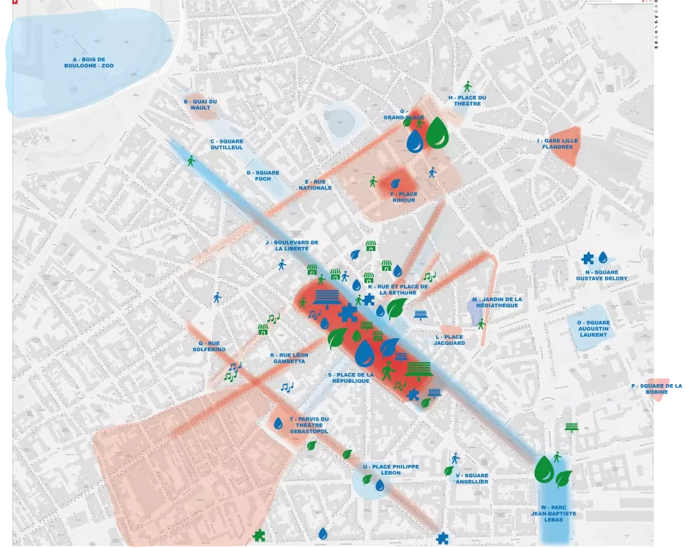
The results showed that seeking coolness, the residents and users of Lille and Loos generally go to parks. Buildings are very rarely considered as refuge spaces, except for shopping centres thanks to air conditioning, their easy access and the possibility of making noise in them. People restrain themselves from physical activities, as well as from shopping and moving around the city – these latter being vital, they make the lives of vulnerable people more complex during heatwaves.
The diagnosis also provided details as to the areas felt as the hottest: the areas of Wazemmes, Moulins, Centre, Lille Sud (in Lille) as well as Kiener and Oliveaux (in Loos). As for cool spaces, no district was designated as having an abundance of them.
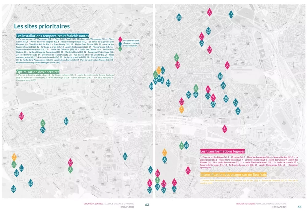
The analysis then concluded in proposed sites for experimentations, while detailing the types of suggested experimentation based on local needs.
Step 3: Bringing it all together
The aim of the third step was to combine the analysis of the two diagnoses to select the sites which would serve as experimentation areas in the next phase of the Time2Adapt project.
3.1 Process
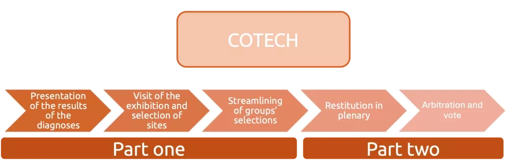
A Technical Committee Meeting with all the partners (COTECH) was organised in October 2024 to present the results of both diagnoses and to prioritise the experimentation sites according to one of the four types of experimentations envisaged in the project:
- Optimisation of opening hours
- light transformations (facilitated access, light equipment, one-off transformations, …)
- new usages on an existing fresh area
- hosting of temporary installations
To familiarise the partners with the results of the diagnoses, these were sent to all the partners before the COTECH.
The COTECH was then divided in two main parts:
- Part 1 - Reflection in groups. The partners were divided in 4 groups, each of them corresponding to a type of experimentation. After a short presentation of the results of the diagnoses, they were invited to stroll through an exhibition showcasing the proposed sites for experimentation extracted from the diagnoses. Partners could select the sites which made sense for the experimentations their group was responsible for. They would then streamline and decide of their choices on a common map.
- Part 2 – Feedback and arbitration in plenary session. Each group reported the locations chosen for its type of experiment. This could open the discussion about missing locations or infeasibility/incompatibility with a contrary project of the type of action on the sites presented. On this basis, each participant was then invited to vote for each of the sites presented.
The next step was to submit this analysis to elected representatives from Lille and Loos during a Steering Committee (COPIL).

This merger of diagnosis was led by MEL with the involvement of EUC and CEREMA and of all the partners.
3.2 Results
Experimentation fiches were discussed with three elected representatives who then revised the selection over the following month. A feasibility study was also carried out by the Lille and Loos city administrations. Both these provided a final decision: they selected those, which they felt were meaningful, before adding other sites.
At the time of writing, the final selection of sites and experimentations are still under final validation in terms of feasibility.
Main takeways
Mapping cool places with complementary tools
At the time of applying for the EUI fund, the team proposed the most innovative approach that was available to it. Now that the project has started, the experimentations of the diagnoses implemented, first learnings acquired but also first exchanges with the transfer partners of the project, other solutions have arisen. The review of the methodology from transfer partners (namely Metropolitan Area of Barcelona and Middleburg) showed that there is room to improve the current physical diagnosis to be more thorough in the criteria chosen to help a better prioritisation of sites. This will be explored through the 2nd phase of the project.
Elected representatives validating the selection
The project anticipated that using both diagnoses, the proposals for sites would be strong enough to push for the elected representatives to select them. This was without considering the own agendas of the elected representatives, not only necessarily relating to their own interests, but with a deeper and longer knowledge of the areas, including about previous or future projects or of some societal (e.g. safety) issues related to those. In the end, and that is the way the local democracy works, they have the final world. Further communication and collaboration need to keep on being elaborated so that all the parties agree on an approach and to avoid frustration. In the light of citizen participation, it will also be crucial to explain the way citizens inputs were (or not) integrated.
The rushed time and timing of the task
Ideally, a physical diagnosis would be undertaken before a citizen one in order to contribute to the selection of sites for the stands and the walks. In addition, the whole planning should start at least in January for activities undertaken in the summer, to avoid any rush but also to ensure flexibility.
Developing specific skills
Other cities wishing to carry out both diagnoses will need to develop or acquire specific skills, for the participatory aspects, as well as both qualitative and quantitate analysis and communication. The methodology might need to be adjusted when such skills do not exist or need to be created.
Integration of the diagnoses
The participatory aspects of the citizen diagnosis could be included in other participatory activities of the involved cities, to streamline on energy and resources, as well as to maximise the attendance rate.
Completing with a third diagnosis ?
The evaluation of the experimentations undertaken in summer 2024, in particular on the opening of schoolyards, stressed the need to consider technical and organisational elements when experimenting: in other terms, is there enough flexibility to make any changes? There could be for example issues of available human resources (e.g. need to reorganise tasks or add some – such as cleaning, including with recruitment needs), logistics (e.g. storage of communication material or installations ), provisioning (e.g. need for extra cleaning products), multiple activities on site (e.g. conflicting creation of installation or storage and ongoing festival) etc. This criterion should not be blocking the selection of a site but rather stress the need to anticipate a solution to an already identified risk.
Thank you!
I would like to thank all the partners who met me to talk about their experiences with the diagnoses: Laure Le Pair, François Lescaux, Elisabeth Lopez, Ophélie Tainguy (MEL), Corentin Ryckelinck (CEREMA), Gabrielle Carpel et Jeanne Zanardo (EUC).
About this resource


The European Urban Initiative is an essential tool of the urban dimension of Cohesion Policy for the 2021-2027 programming period. The initiative established by the European Union supports cities of all sizes, to build their capacity and knowledge, to support innovation and develop transferable and scalable innovative solutions to urban challenges of EU relevance.

Similar content