Summary
There is a long tradition of place-based approaches in cohesion policy but it has been made more explicit in the 2014-20 period with the adoption of Article 7, whether delivered through a programme, a multi-themed axis, or through the new territorial tools of Integrated Territorial Investments (ITI) and Community-led Local Development (CLLD).
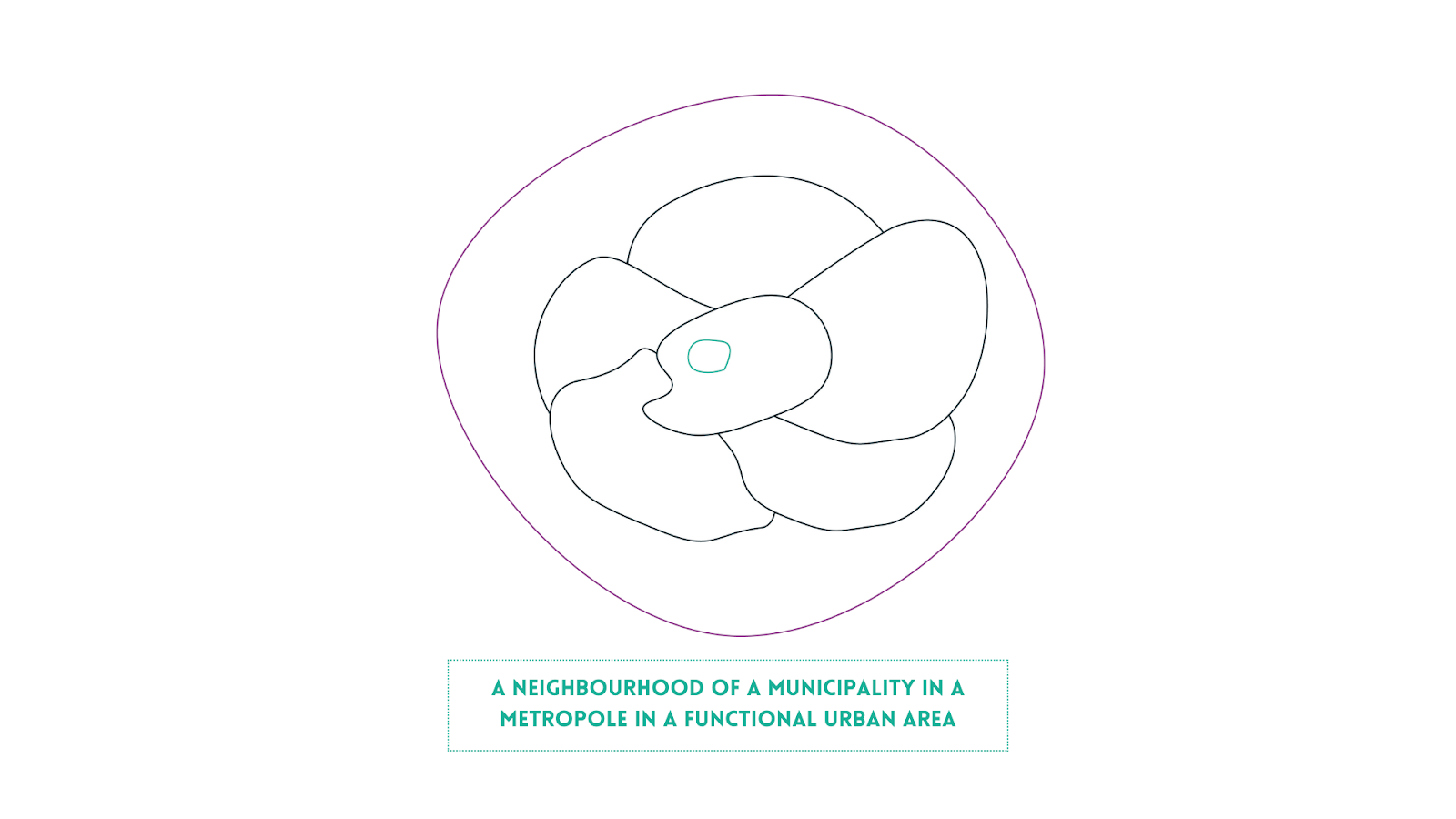
European cities face many challenges that manifest at different spatial scales. In UIA projects these are typically the neighbourhood, the municipality and the metropolitan area. It is in these places that policies are integrated, and that partnerships are built with the integration of horizontal and vertical communities of stakeholders.
This chapter explores a selection of UIA projects from the point of view of the place-based approach. After an overview of definitions, the following pages examine the key methods and tools that cities use to implement integrated projects locally. The section is concluded by an in-depth look into a number of good practices and collects a set of takeaways.

Map of assets in the Birmingham -Smethwick area of the Use-It! project
There is a long tradition of place-based approaches in cohesion policy but it has been made more explicit in the 2014-20 period with the adoption of Article 7, whether delivered through a programme, a multi-themed axis, or through the new territorial tools of Integrated Territorial Investments (ITI) and Community-led Local Development (CLLD).
European cities face many challenges that manifest at different spatial scales. In UIA projects these are typically the neighbourhood, the municipality and the metropolitan area. It is in these places that policies are integrated, and that partnerships are built with the integration of horizontal and vertical communities of stakeholders.
This chapter explores a selection of UIA projects from the point of view of the place-based approach. After an overview of definitions, the following pages examine the key methods and tools that cities use to implement integrated projects locally. The section is concluded by an in-depth look into a number of good practices and collects a set of takeaways.
Map of assets in the Birmingham -Smethwick area of the Use-It! project
Definitions and interpretations of the place-based approach
“Places should be regarded as reference points for an integrated horizontal and vertical approach.” (The New Leipzig Charter, p.8)
The notion of a place-based approach has been explicit in the delivery of regionally-based cohesion policy through concentration of resources in the poorest regions. However, it was given new impetus by the 2009 report of Fabrizio Barca in which he made the place-based approach the centrepiece for his idea of a reformed cohesion policy and sees the chance to unlock endogenous potential. Barca’s notion of place- based referred to the regional or functional urban area level and in his formulation the vertical chain is about grants being devolved from European level to Member State to regions with conditionalities.
In the New Leipzig Charter there is emphasis on what they term sound analysis of the specific local situation.
“Urban strategies and urban funding instruments should be based on sound analysis of the specific local situation, especially potential benefits and risks, stakeholders and restrictions while following place-based development.” (The New Leipzig Charter, p.8)
The place-based approach needs quality territorial data to inform the implementation of policy. Ideally this data is more granular than the scale of the territory chosen for implementation. This means that if the city is the unit for implementation, then neighbourhood data is needed on the topic. The strongest projects developed a clear understanding of the assets and deficits in their area through mapping and data.
“Appropriate formal and informal instruments should cover all spatial levels, from neighbourhoods to local authorities and wider functional areas including the metropolitan level. “ (The New Leipzig Charter, p.8)
It is worth noting that not all problems fall neatly into the spatial categories specified by administrative boundaries. For example, deprived areas frequently overlap municipal boundaries. Transit systems and waste management frequently cover several adjacent municipalities. As JRC points out in their handbook on sustainable urban development strategies, there is a gap between where people live and where they work. Cities attempt to manage this by providing mobility solutions and individuals make their own choices of transport mode. This gap also applies to other aspects of daily life where people live in a different place from where their energy is produced; where they engage with culture, recreation, leisure and shopping. This spatial dislocation becomes harder to manage because many urban areas are fragmented by ancient boundaries. Municipalities are exploring ways to provide spatially coherent responses through association agreements with the neighbouring municipalities. At the same time digitisation is transforming and relocalising some of these functions including leisure and working from home. Even home energy production may now be on solar panels on the roof.
The main research questions relating to the place-based approach were:
- How did cities define the territorial scale of intervention for complex interventions and what issues did they face?
- How to achieve concentration of resources on a specific territory while considering that issues and opportunities are not confined by neighbourhood or administrative boundaries?
- Were all activities concentrated in one specific area? Were these complemented by other measures in surrounding areas?
The place-based approach is inextricably linked to the partnership that can be brought together to address a particular problem. The multi-level and multi-stakeholder partnership is dealt with in section 3 and includes both bringing in multiple stakeholders from departments and agencies within the area and also from other levels of government. The partnership is in turn linked to the nature of the problem being addressed and the range of cross-sectoral policies required to tackle it.
The choice of which territorial scale to operate at is linked to the nature of the challenge and the cross- sectoral mix of policies that are needed to address it. Typically, solutions exist at larger territories than problems which are often highly concentrated for example in deprived neighbourhoods.
Analysis from the case studies and key takeaways
Cities defined their territorial scale in different ways. Birmingham, Lyon, Ravenna Dare, and Viladecans chose neighbourhoods as their main territorial focus for the project (see Table 1). Note that although both the Leipzig charter and the JRC Handbook refer to functional urban areas (FUA), the largest scale that the 12 case study UIA projects operated at was the metropolitan area, or metropole, which is normally much smaller than an FUA
Table 1: Territorial scale of case study interventions ( “x”s refer to the number of sites)

There was no close link between the two levels of intervention, although Pata Rat residents could participate in other parts of the project. In Vilawatt in Viladecans, the main intervention on housing improvement was in a small part of the Montserratina neighbourhood. It was chosen because it is a disadvantaged area with low incomes and with poorly insulated housing built before the 1970s when building regulations on energy efficiency were first enacted. Sixty 60 dwellings had their energy efficiency improved by insulating windows and draught-proofing. Other aspects of the project, including the dissemination and training activities on energy efficiency and the alternative currency Vilawatt, applied across the whole neighbourhood and later extended to the whole city.
Prato Urban Jungle Operates In Different Test LocationsPrato initially selected three different locations for its urban jungles. These were the St Giusto housing estate, in a relatively deprived neighbourhood, the Macrolotto zero area, which had already benefited from support under the Italian Article 7 programme (supporting integrated SUDs) and the ESTRA office site of a private company. Later during the implementation, a site at Via delle Pleiadi was added, although this is directly funded by the municipality. In each of the four places, a different jungle solution was proposed. For St Giusto, it is a vertical garden climbing from the ground to the top of the six-storey apartment buildings. A new entrance area will also be landscaped. The second area is the Macrolotto zero site which is a former industrial area for fast fashion, which has been extensively remodelled using ERDF. The urban jungle project created a permeable horizontal shady roof structure to complement improvements to the buildings and the public realm. For Via delle Pleiadi, the idea is to transform a grassed space left over after the development of new shopping facilities into a landscaped space with amenities and trees that can act as a neighbourhood focus for both formal and informal get togethers. The new layout will green the area and create people-friendly meeting space. The purpose of having such different places is to test the urban jungle concept in different environments so that the city’s ambition to become a forested city can be achieved. This was explained during the hearings by a representative from the city: “Of course, we decided to test these innovative solutions on three different pilots, from various eras, and, one of those was on social housing for the buildings, and the other one was on their own private enterprise. So we pretty much involved ESTRA as a partner in this step, because we also wanted to work on the benefits for employees and SMEs. And then Macrolotto zero, was in a very problematic area of the city that is characterised as an industrial area with a lot of big buildings that are not used anymore. And where we don't have a lot of green areas, and also with social problems in the area, we also have the settlement of the big Chinese community. And so we also had to work on integration and besides on the greening of the Area. “ PUJ Municipality representative |
The reasons for selection of multiple areas varied. Utrecht’s Plan Einstein initially focused on a single, relatively deprived and ethnically mixed neighbourhood in Overvecht. However, the city had committed to keeping the new centre open for only 2 years in the face of initial objections and the lease on the building was signed on that basis.
This activity ended when the relocation to a more prosperous neighbourhood of Haydn took place in the final year of the project. In contrast, Prato Urban Jungle chose four main locations for the implementation of its urban jungles (see previous box) with the intention of testing their urban jungle concept in different types of locations. Three of these were selected at the outset with Via delle Pleiadi being added later.
In Paris, ten schools were chosen for the OASIS project to combat the heat island effect. The majority of Parisians live within 200m of one of the 760 infant, junior or middle schools, which appeared as key central points to implement the resilience strategy. Although the policy applied all over the city, priority was given to schools that met a series of selection criteria, which included lack of green space in the neighbourhood, deprivation, demographics, and temperature profiles during heatwaves (see box below).
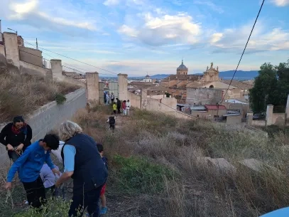
Projects to tackle deprivation have often been spatially concentrated or “area-based”. This concentration is partly because few cities can afford to invest in measures across the city, but also because deprivation itself is often concentrated, even when the causes may be city wide. Although spatial concentration was an issue for many of the case study cities, opportunities are often further afield. In USE-IT! Birmingham’s Icknield area, a new hospital is being constructed in Smethwick, outside the target area of the project, but offering job opportunities for residents of the area. For the residents of Pata Rât in CFW Cluj nearly all the future economic opportunities will be in the city, not at the landfill where many have worked for years. Accessing the jobs in the city was improved by the new bus service, better sanitation facilities and free wifi at the camp.
The School As The Centre Of The Neighbourhood And The Focus Of The 15 Minute CityIn Paris, the OASIS project improved ten schoolyards across the city to create cool oases that can be used by the local community during heat waves when the heat island effect is most severe. They also serve as amenities for use by the local community on Saturdays and by the children on every school day. As mentioned, the majority of citizens in Paris live close to school yards, and for this reason schools have been placed at the centre of Mayor Hidalgo’s 15-minute city policy. Schoolyards are being made multi-purpose as an amenity for the local neighbourhood not just in times of extreme heat and not only for the children. Paris has the highest density of any city in Europe and only 5.8sqm of open space per citizen, so schools are valuable urban spaces. A further 60 schools are planned with about a dozen to be completed each year. Detailed data is collected and mapped by partners in the project, including Meteo France, the French national meteorological service. This enables parts of the city most susceptible to the heat island effect to be mapped alongside data on which neighbourhoods are most lacking open green spaces. This enabled the first batch of schools to be selected in neighbourhoods that were most in need of more facilities. Why schools were chosen was explained by the project coordinator : “Participants had to imagine what resources they could work from, and they identified the public facilities that are the closest to everyone. So schools appeared as the centre of the neighbourhoods, the heart of the neighbourhood, a place where people are close to, where they have habits, and where they can gather in case of a crisis. And this was the starting point. But then we started to think okay, but we can also face all the other challenges that we had identified in the resilience strategy”. OASIS Municipality representative
OASIS renovated schoolyards |

Key takeaway 1
Text
The scale of the area of intervention should be selected to bring policies together in an integrated approach and to maximise impact while taking account of other relevant factors. Sometimes a two level approach is needed especially if solutions are more widely distributed than the targeted place. This means that some investments, for example a bus service to help people from a disadvantaged neighbourhood to access work might be outside the target area.
The scale of the area of intervention should be selected to bring policies together in an integrated approach and to maximise impact while taking account of other relevant factors. Sometimes a two level approach is needed especially if solutions are more widely distributed than the targeted place. This means that some investments, for example a bus service to help people from a disadvantaged neighbourhood to access work might be outside the target area.
Cities varied in the attention they paid to analyse the local situation when designing their projects. In some cases, there was a recognition that previous approaches had to some extent failed. This was the case with the area chosen for Birmingham’s USE-IT! where despite decades of interventions under a range of schemes, the fundamental problems of poverty and its links to worklessness had not been sufficiently addressed (see box below). For DARE Ravenna’s Darsena area, the previous interventions had been physically based ranging from architect’s Master Plans to the “Darsena I wish” integrated strategy and the Darsena City Operative Plan. Despite having participative aspects, these plans and programmes prioritised architectural and buildings above enterprise and people. DARE mapped the local area in terms of its policies, programmes and assets. Through the DARE project they were able to implement new digital technologies to open up the area. Both Birmingham and Ravenna have chosen a radical departure from what had come before based on a new understanding about the needs of the area.
Geographic or place-based data is changing rapidly with the advent of new technologies. Lahti’s CitiCap was able to use real-time movement data recorded by an app using the GPS and other movement features of a mobile phone. This raw data can be converted into modal split transport data to provide an estimation of the carbon saving each person was making on their personal account by using active travel. Projects may also generate their own geographic data through studies. Following the approval of the project, Cluj CFW embarked on a range of studies during the implementation of the project to deepen their understanding of the culture and creative and digital sectors in the city and its relationship to sectors under threat. These studies carried out by independent consultants, mostly from local universities, had to be conducted quickly as the results fed into the next phases of the project.
Researching The Assets And Challenges Of A Place To Understand Its DynamicsUSE-IT! Birmingham set out on a quintessential place-based approach focusing on an area that had already been the subject of previous physical regeneration programmes. Their model of economic development was influenced by work done in the 2000s by the New Economics Foundation which described local economies as leaky buckets and more recently by the Centre for Economic Strategies with its emphasis on community wealth building. Their argument is that previous waves of regeneration spending had failed to make a difference to the Icknield community in West Birmingham/Smethwick because despite considerable spending on physical investments too few of the benefits remained in the local area. The Community wealth building approach starts by analysing what anchor institutions are doing in terms of spending and employment in the locality, then exploring how this can be increased and prospecting with local social enterprises to explore how this expenditure can be used to create more opportunities for local people. Two institutions were particularly important to the area: the University and the local hospital, both large public institutions that can be seen as anchors for the local economy. Both recognised that they could do more to develop the communities in which they operate by skilful reviews of how they purchase goods and services without compromising quality or price. "Regarding the university, it is important to note that although the campus is not located in that area, they have been working there for many years, consequently their knowledge and involvement in the neighbourhood is profound." USE-IT! Project coordinator Birmingham’s USE-IT! project trained and accredited local people as Community Researchers who could identify potential new markets for social enterprise in the designated area. They went on to facilitate the gathering of groups who could spin-off new enterprises. Along the way 72 people were trained with an accredited qualification and of these one went on to do a PhD and three to Masters programmes. These accredited researchers worked with University academics to deliver research for clients from across the region. Support for the local economy included establishing and supporting social enterprises to grow and embedding them in local markets including the development of a peer network of social entrepreneurs, engagement and market development with anchor institutions, business support programmes and business mentors and coaches. |
Key Takeaway 2
Text
Granular and timely territorialised data underpins the place based approach. High quality up-to-date granular data is necessary for the place-based approach. CityCap Lahti has movement data available by mode of transport. USE-IT! Birmingham was able to generate data on local economic potential using locally trained researchers.
Granular and timely territorialised data underpins the place based approach. High quality up-to-date granular data is necessary for the place-based approach. CityCap Lahti has movement data available by mode of transport. USE-IT! Birmingham was able to generate data on local economic potential using locally trained researchers.
Spatial concentration, by which we mean the focus of resources on parts of cities such as neighbourhoods is part of the place-based approach. But it does not always mean that all investments should take place in the neighbourhood itself. There may be advantages for certain measures to operate at other normally larger scales.
In Vilawatt Viladecans, the main physical investment of conversion and insulating properties took place in La Montserratina which has a population of about 20,000 people, a third of the population of the city as a whole and around 8,000 dwellings. The actual renovation work was focused on a small area within La Montserratina, improving 60 units for about €1.4million. However, other aspects of the project benefit the city as a whole. These include the PPCP or public-private-community partnership, energy supply from solar generated electricity, energy consultancy advisory service, and the implementation of the local currency Vilawatt. All these services are open to all citizens and local enterprises based in the city.
When looking at employment opportunities these are often further afield. In USE-IT! Birmingham’s Icknield area, a new West Midlands Metropolitan hospital was being constructed in Smethwick, outside the target area of the project but a source of construction jobs and future jobs in health especially for migrant residents of the area. For the residents of Pata Rât in CFW Cluj nearly all the future economic opportunities will be in the city, not on the landfill where many have worked for decades.
External factors can impinge on the place-based approach. For example, air pollution is not only determined by car cultures and behaviour within an area but may come from beyond the municipality when it is part of a larger conurbation (see Portici, as an example). Greening of parts of cities can make them more attractive but could also lead to gentrification to the detriment of long-standing residents. This is a potential risk in PUJ Prato, though one that the city is aware of. National regulation can affect how innovative financial instruments are used and may cause residents issues with taxes and benefits. This had to be managed in both Viladecans and Lahti. Utrecht had to work within the national refugee reception context set by COA, the refugee reception agency and in their second location at Haydn had less freedom to operate as the building offered fewer opportunities – for example, there was no space for young people to live alongside refugees.
Key Takeaway 3
Text
When using the place-based approach at neighbourhood level, consider what is the best spatial scale for different types of support. Often the neighbourhood level is chosen because of the concentration of problems in the area and also to concentrate available resources. However, it does not follow that all territorial investments should be at this scale.
When using the place-based approach at neighbourhood level, consider what is the best spatial scale for different types of support. Often the neighbourhood level is chosen because of the concentration of problems in the area and also to concentrate available resources. However, it does not follow that all territorial investments should be at this scale.
In most projects operating at the neighbourhood level considerable effort was made to engage with local communities. In Pata Rât in Cluj, the community mediators conducted surveys and operated a participative budgeting process to enable residents to prioritise spending on investments that mattered to them. As a result of the participatory budgeting exercise residents chose new sanitary units, free wifi delivered through masts in the area and a bus service was diverted to stop near the camps. The bus transport which was free until November 2021 was one example that was explicitly designed to help residents get to work in other parts of the city. The new sanitation units also helped the residents to feel better about their personal appearance at work.
Cities made considerable efforts to build local partners into the management of their schemes. A good example was Lyon’s Home Silk Road, where the local innovation centre CCO Villeurbanne has played a critical role in organising participation of citizens, events and creating a local culture of memory. Also in France, the Ligue de l’enseignement organised links between the schools and the local community for the ten pilot schools in the Paris Oasis project. This was followed up by intensive design work involving architects, students, parents and teachers. In Viladecans, new forms of associative energy companies have been created at the local level in the La Montserratina district. New participative approaches often require new institutional structures and the Public Private Community Partnership (discussed in Section 2) is a good example of this.
Utrecht had an outreach team that built links with civil society organisations in the neighbourhood. Regular social events in the yard/garden, often involving food, helped to bring people into the centre so that instead of fearing it they started to embrace it. Meanwhile, the formal education provision for English, business and entrepreneurship classes insisted that local people made up a minimum of 20% of participants. This helped the refugees in the centre to get to know some Dutch people. Something that rarely happens in the out-of-town reception centres. Approximately 30 young people lived in an adjacent building as part of the Plan Einstein project. They were incentivised through a rent reduction to organise and participate in social activities. This worked for some people but less so for others.
At the opposite extreme, Utrecht wanted to test a new approach to the integration of refugees living in nationally funded refugee reception centres. Most refugee reception centres in the Netherlands are located in out of town spaces, for example in former army barracks. The originators of the project wanted to challenge this logic by placing a refugee reception centre right in the middle of Utrecht. The first centre was in a converted former office building in Overvecht, a neighbourhood of Utrecht with a multi-ethnic population.
Key takeaway 4
Text
Each place is unique with its own challenges, culture, organisations and potential. Place-based approaches have to be carefully adapted to their setting and can do so by engaging meaningfully with local groups. The specificities of place are such that projects need to be carefully adapted in each setting. For complex projects this requires an understanding of what has gone before, what worked and what did not, and of the labyrinth of organisations and enterprises that are there. In their early stages project teams need to take on a listening role to best understand how the project can work.
Each place is unique with its own challenges, culture, organisations and potential. Place-based approaches have to be carefully adapted to their setting and can do so by engaging meaningfully with local groups. The specificities of place are such that projects need to be carefully adapted in each setting. For complex projects this requires an understanding of what has gone before, what worked and what did not, and of the labyrinth of organisations and enterprises that are there. In their early stages project teams need to take on a listening role to best understand how the project can work.
About this resource
The Urban Innovative Actions (UIA) is a European Union initiative that provided funding to urban areas across Europe to test new and unproven solutions to urban challenges. The initiative had a total ERDF budget of €372 million for 2014-2020.

Similar content